You are here: Home > Network List > UW - Pacific Northwest Regional Seismic Network Stations List
> Station HOOD Mt Hood Meadows, OR CREST BB SMO > Earthquake Result Viewer
HOOD Mt Hood Meadows, OR CREST BB SMO - Earthquake Result Viewer

| Earthquake location: |
Near Coast Of Peru |
| Earthquake latitude/longitude: |
-13.4/-76.6 |
| Earthquake time(UTC): |
2007/08/15 (227) 23:40:57 GMT |
| Earthquake Depth: |
39 km |
| Earthquake Magnitude: |
6.7 MB, 7.9 MS, 8.0 MW, 7.5 ME |
| Earthquake Catalog/Contributor: |
WHDF/NEIC |
|
| Network: |
UW Pacific Northwest Regional Seismic Network |
| Station: |
HOOD Mt Hood Meadows, OR CREST BB SMO |
| Lat/Lon: |
45.32 N/121.65 W |
| Elevation: |
1520 m |
|
| Distance: |
71.2 deg |
| Az: |
328.17 deg |
| Baz: |
133.323 deg |
| Ray Param: |
0.054411735 |
| Estimated Moho Depth: |
35.5 km |
| Estimated Crust Vp/Vs: |
1.85 |
| Assumed Crust Vp: |
6.597 km/s |
| Estimated Crust Vs: |
3.576 km/s |
| Estimated Crust Poisson's Ratio: |
0.29 |
|
| Radial Match: |
93.70819 % |
| Radial Bump: |
400 |
| Transverse Match: |
88.55818 % |
| Transverse Bump: |
400 |
| SOD ConfigId: |
2564 |
| Insert Time: |
2010-02-27 04:24:53.630 +0000 |
| GWidth: |
2.5 |
| Max Bumps: |
400 |
| Tol: |
0.001 |
|
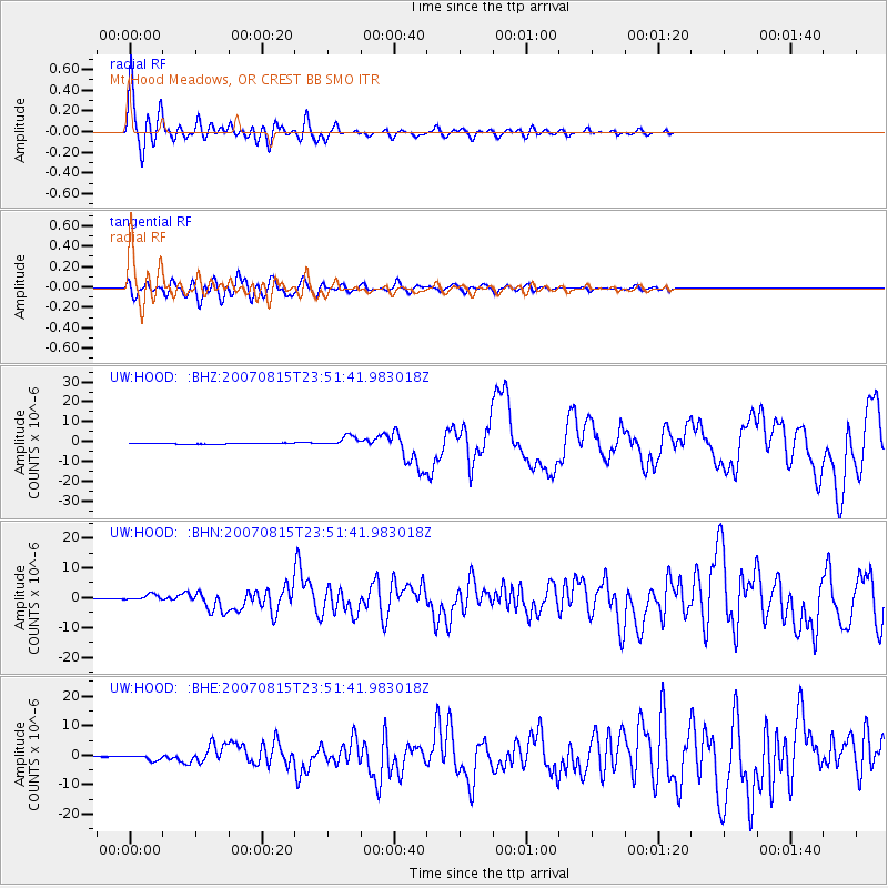
Signal To Noise
| Channel | StoN | STA | LTA |
| UW:HOOD: :BHN:20070815T23:51:41.983018Z | 6.5581613 | 1.1036556E-6 | 1.6828733E-7 |
| UW:HOOD: :BHE:20070815T23:51:41.983018Z | 9.615303 | 1.0919944E-6 | 1.1356838E-7 |
| UW:HOOD: :BHZ:20070815T23:51:41.983018Z | 12.6106615 | 2.6810515E-6 | 2.1260198E-7 |
| Arrivals |
| Ps | 4.7 SECOND |
| PpPs | 15 SECOND |
| PsPs/PpSs | 19 SECOND |


