You are here: Home > Network List > UW - Pacific Northwest Regional Seismic Network Stations List
> Station HOOD Mt Hood Meadows, OR CREST BB SMO > Earthquake Result Viewer
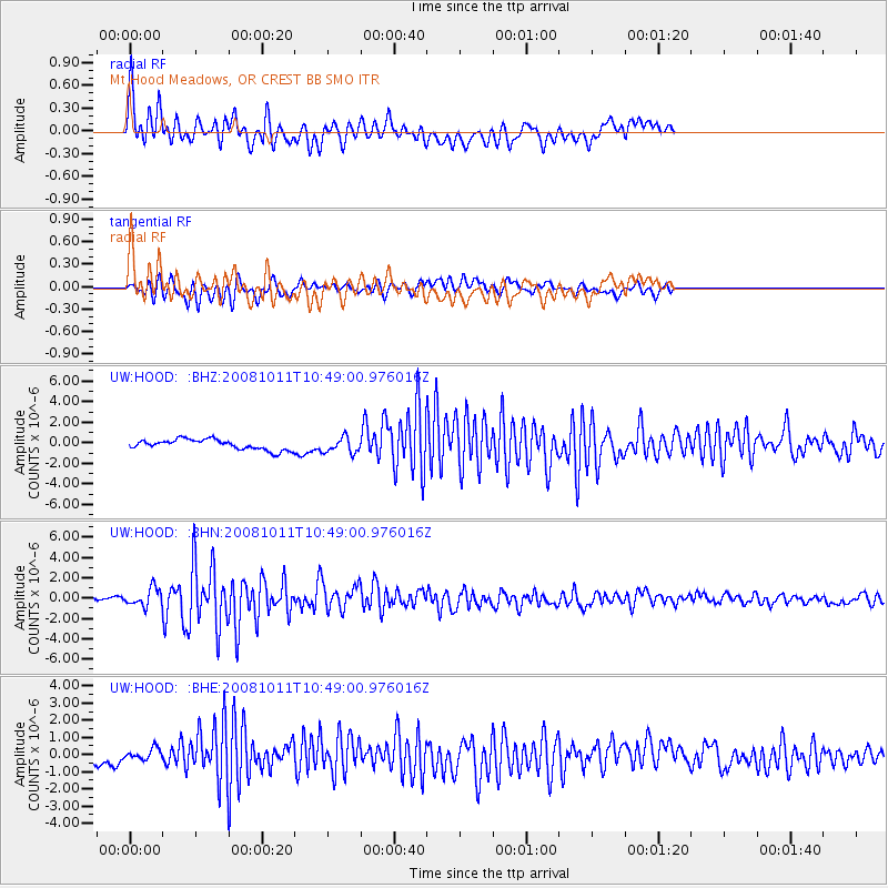
HOOD Mt Hood Meadows, OR CREST BB SMO - Earthquake Result Viewer
*The percent match for this event was below the threshold and hence no stack was calculated.
| Earthquake location: |
Virgin Islands |
| Earthquake latitude/longitude: |
19.2/-64.8 |
| Earthquake time(UTC): |
2008/10/11 (285) 10:40:14 GMT |
| Earthquake Depth: |
23 km |
| Earthquake Magnitude: |
6.1 MB, 5.9 MS, 6.1 MW, 6.0 MW |
| Earthquake Catalog/Contributor: |
WHDF/NEIC |
|
| Network: |
UW Pacific Northwest Regional Seismic Network |
| Station: |
HOOD Mt Hood Meadows, OR CREST BB SMO |
| Lat/Lon: |
45.32 N/121.65 W |
| Elevation: |
1520 m |
|
| Distance: |
53.4 deg |
| Az: |
312.651 deg |
| Baz: |
99.785 deg |
| Ray Param: |
$rayparam |
*The percent match for this event was below the threshold and hence was not used in the summary stack. |
|
| Radial Match: |
79.69593 % |
| Radial Bump: |
400 |
| Transverse Match: |
67.99925 % |
| Transverse Bump: |
400 |
| SOD ConfigId: |
2556 |
| Insert Time: |
2010-02-27 04:25:01.016 +0000 |
| GWidth: |
2.5 |
| Max Bumps: |
400 |
| Tol: |
0.001 |
|
Signal To Noise
| Channel | StoN | STA | LTA |
| UW:HOOD: :BHN:20081011T10:49:00.976016Z | 5.858703 | 8.785241E-7 | 1.4995197E-7 |
| UW:HOOD: :BHE:20081011T10:49:00.976016Z | 0.7769322 | 3.150639E-7 | 4.0552302E-7 |
| UW:HOOD: :BHZ:20081011T10:49:00.976016Z | 1.518589 | 7.559648E-7 | 4.978074E-7 |
| Arrivals |
| Ps | |
| PpPs | |
| PsPs/PpSs | |


