You are here: Home > Network List > TA - USArray Transportable Network (new EarthScope stations) Stations List
> Station N45A Kentland, IN, USA > Earthquake Result Viewer
N45A Kentland, IN, USA - Earthquake Result Viewer
| Earthquake location: |
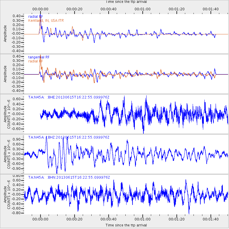
Crete, Greece |
| Earthquake latitude/longitude: |
34.4/25.0 |
| Earthquake time(UTC): |
2013/06/15 (166) 16:11:02 GMT |
| Earthquake Depth: |
10 km |
| Earthquake Magnitude: |
6.2 MW, 6.0 MB, 6.0 MS, 6.1 MW |
| Earthquake Catalog/Contributor: |
NEIC PDE/NEIC PDE-W |
|
| Network: |
TA USArray Transportable Network (new EarthScope stations) |
| Station: |
N45A Kentland, IN, USA |
| Lat/Lon: |
40.85 N/87.51 W |
| Elevation: |
206 m |
|
| Distance: |
82.8 deg |
| Az: |
315.062 deg |
| Baz: |
50.345 deg |
| Ray Param: |
0.046664257 |
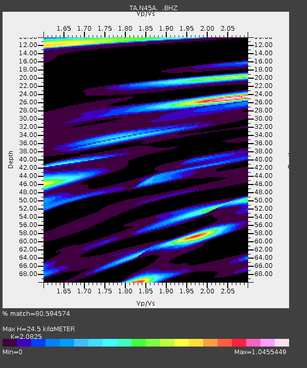
| Estimated Moho Depth: |
24.5 km |
| Estimated Crust Vp/Vs: |
2.08 |
| Assumed Crust Vp: |
6.498 km/s |
| Estimated Crust Vs: |
3.12 km/s |
| Estimated Crust Poisson's Ratio: |
0.35 |
|
| Radial Match: |
80.594574 % |
| Radial Bump: |
400 |
| Transverse Match: |
52.082577 % |
| Transverse Bump: |
400 |
| SOD ConfigId: |
512894 |
| Insert Time: |
2013-09-15 04:18:04.860 +0000 |
| GWidth: |
2.5 |
| Max Bumps: |
400 |
| Tol: |
0.001 |
|
Signal To Noise
| Channel | StoN | STA | LTA |
| TA:N45A: :BHZ:20130615T16:22:55.099976Z | 3.9634285 | 4.5720947E-7 | 1.1535706E-7 |
| TA:N45A: :BHN:20130615T16:22:55.099976Z | 1.5459665 | 1.8601023E-7 | 1.203197E-7 |
| TA:N45A: :BHE:20130615T16:22:55.099976Z | 1.9556874 | 1.882172E-7 | 9.624094E-8 |
| Arrivals |
| Ps | 4.2 SECOND |
| PpPs | 11 SECOND |
| PsPs/PpSs | 16 SECOND |


