You are here: Home > Network List > TA - USArray Transportable Network (new EarthScope stations) Stations List
> Station S44A Carbondale, IL, USA > Earthquake Result Viewer
S44A Carbondale, IL, USA - Earthquake Result Viewer
| Earthquake location: |
Crete, Greece |
| Earthquake latitude/longitude: |
34.4/25.0 |
| Earthquake time(UTC): |
2013/06/15 (166) 16:11:02 GMT |
| Earthquake Depth: |
10 km |
| Earthquake Magnitude: |
6.2 MW, 6.0 MB, 6.0 MS, 6.1 MW |
| Earthquake Catalog/Contributor: |
NEIC PDE/NEIC PDE-W |
|
| Network: |
TA USArray Transportable Network (new EarthScope stations) |
| Station: |
S44A Carbondale, IL, USA |
| Lat/Lon: |
37.69 N/89.26 W |
| Elevation: |
155 m |
|
| Distance: |
85.8 deg |
| Az: |
313.527 deg |
| Baz: |
49.093 deg |
| Ray Param: |
0.044484682 |
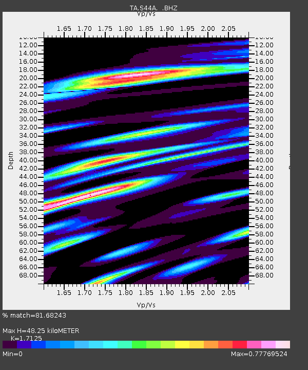
| Estimated Moho Depth: |
48.25 km |
| Estimated Crust Vp/Vs: |
1.71 |
| Assumed Crust Vp: |
6.444 km/s |
| Estimated Crust Vs: |
3.763 km/s |
| Estimated Crust Poisson's Ratio: |
0.24 |
|
| Radial Match: |
81.68243 % |
| Radial Bump: |
400 |
| Transverse Match: |
62.255474 % |
| Transverse Bump: |
400 |
| SOD ConfigId: |
512894 |
| Insert Time: |
2013-09-15 04:22:34.321 +0000 |
| GWidth: |
2.5 |
| Max Bumps: |
400 |
| Tol: |
0.001 |
|

Signal To Noise
| Channel | StoN | STA | LTA |
| TA:S44A: :BHZ:20130615T16:23:10.599976Z | 6.478607 | 6.1984395E-7 | 9.5675496E-8 |
| TA:S44A: :BHN:20130615T16:23:10.599976Z | 1.876766 | 2.3419835E-7 | 1.2478826E-7 |
| TA:S44A: :BHE:20130615T16:23:10.599976Z | 2.0287929 | 2.9245277E-7 | 1.4415113E-7 |
| Arrivals |
| Ps | 5.5 SECOND |
| PpPs | 20 SECOND |
| PsPs/PpSs | 25 SECOND |


