You are here: Home > Network List > TA - USArray Transportable Network (new EarthScope stations) Stations List
> Station T47A Sharon Grove, KY, USA > Earthquake Result Viewer
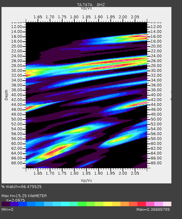
T47A Sharon Grove, KY, USA - Earthquake Result Viewer
| Earthquake location: |
Crete, Greece |
| Earthquake latitude/longitude: |
34.4/25.0 |
| Earthquake time(UTC): |
2013/06/15 (166) 16:11:02 GMT |
| Earthquake Depth: |
10 km |
| Earthquake Magnitude: |
6.2 MW, 6.0 MB, 6.0 MS, 6.1 MW |
| Earthquake Catalog/Contributor: |
NEIC PDE/NEIC PDE-W |
|
| Network: |
TA USArray Transportable Network (new EarthScope stations) |
| Station: |
T47A Sharon Grove, KY, USA |
| Lat/Lon: |
36.99 N/87.11 W |
| Elevation: |
217 m |
|
| Distance: |
85.0 deg |
| Az: |
311.876 deg |
| Baz: |
50.259 deg |
| Ray Param: |
0.045095213 |
| Estimated Moho Depth: |
15.25 km |
| Estimated Crust Vp/Vs: |
2.10 |
| Assumed Crust Vp: |
6.444 km/s |
| Estimated Crust Vs: |
3.072 km/s |
| Estimated Crust Poisson's Ratio: |
0.35 |
|
| Radial Match: |
86.475525 % |
| Radial Bump: |
344 |
| Transverse Match: |
64.01886 % |
| Transverse Bump: |
400 |
| SOD ConfigId: |
512894 |
| Insert Time: |
2013-09-15 04:23:38.581 +0000 |
| GWidth: |
2.5 |
| Max Bumps: |
400 |
| Tol: |
0.001 |
|

Signal To Noise
| Channel | StoN | STA | LTA |
| TA:T47A: :BHZ:20130615T16:23:06.374023Z | 6.6819468 | 7.9131496E-7 | 1.184258E-7 |
| TA:T47A: :BHN:20130615T16:23:06.374023Z | 2.188166 | 2.2409543E-7 | 1.0241245E-7 |
| TA:T47A: :BHE:20130615T16:23:06.374023Z | 2.6820736 | 2.2545842E-7 | 8.4061234E-8 |
| Arrivals |
| Ps | 2.7 SECOND |
| PpPs | 7.2 SECOND |
| PsPs/PpSs | 9.8 SECOND |


