You are here: Home > Network List > TA - USArray Transportable Network (new EarthScope stations) Stations List
> Station W46A Michie, TN, USA > Earthquake Result Viewer
W46A Michie, TN, USA - Earthquake Result Viewer
| Earthquake location: |
Crete, Greece |
| Earthquake latitude/longitude: |
34.4/25.0 |
| Earthquake time(UTC): |
2013/06/15 (166) 16:11:02 GMT |
| Earthquake Depth: |
10 km |
| Earthquake Magnitude: |
6.2 MW, 6.0 MB, 6.0 MS, 6.1 MW |
| Earthquake Catalog/Contributor: |
NEIC PDE/NEIC PDE-W |
|
| Network: |
TA USArray Transportable Network (new EarthScope stations) |
| Station: |
W46A Michie, TN, USA |
| Lat/Lon: |
35.13 N/88.38 W |
| Elevation: |
145 m |
|
| Distance: |
87.0 deg |
| Az: |
311.124 deg |
| Baz: |
49.46 deg |
| Ray Param: |
0.043671153 |
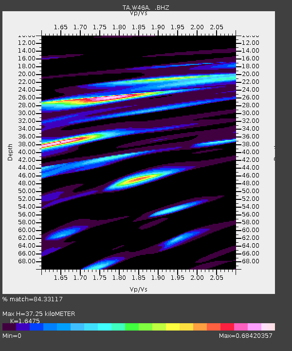
| Estimated Moho Depth: |
37.25 km |
| Estimated Crust Vp/Vs: |
1.65 |
| Assumed Crust Vp: |
6.38 km/s |
| Estimated Crust Vs: |
3.873 km/s |
| Estimated Crust Poisson's Ratio: |
0.21 |
|
| Radial Match: |
84.33117 % |
| Radial Bump: |
400 |
| Transverse Match: |
70.60562 % |
| Transverse Bump: |
400 |
| SOD ConfigId: |
512894 |
| Insert Time: |
2013-09-15 04:26:30.023 +0000 |
| GWidth: |
2.5 |
| Max Bumps: |
400 |
| Tol: |
0.001 |
|

Signal To Noise
| Channel | StoN | STA | LTA |
| TA:W46A: :BHZ:20130615T16:23:16.150024Z | 6.0831723 | 5.1825657E-7 | 8.519512E-8 |
| TA:W46A: :BHN:20130615T16:23:16.150024Z | 1.7711129 | 2.3186757E-7 | 1.3091632E-7 |
| TA:W46A: :BHE:20130615T16:23:16.150024Z | 2.132818 | 1.8216899E-7 | 8.5412346E-8 |
| Arrivals |
| Ps | 3.9 SECOND |
| PpPs | 15 SECOND |
| PsPs/PpSs | 19 SECOND |


