You are here: Home > Network List > AK - Alaska Regional Network Stations List
> Station MESA Mesa, AK, USA > Earthquake Result Viewer
MESA Mesa, AK, USA - Earthquake Result Viewer
| Earthquake location: |
Near Coast Of Nicaragua |
| Earthquake latitude/longitude: |
11.8/-86.9 |
| Earthquake time(UTC): |
2013/06/15 (166) 17:34:27 GMT |
| Earthquake Depth: |
30 km |
| Earthquake Magnitude: |
6.5 MW, 6.1 MB, 6.3 MS, 6.5 MW |
| Earthquake Catalog/Contributor: |
NEIC PDE/NEIC PDE-W |
|
| Network: |
AK Alaska Regional Network |
| Station: |
MESA Mesa, AK, USA |
| Lat/Lon: |
60.18 N/141.95 W |
| Elevation: |
1919 m |
|
| Distance: |
62.9 deg |
| Az: |
332.601 deg |
| Baz: |
115.629 deg |
| Ray Param: |
0.059898164 |
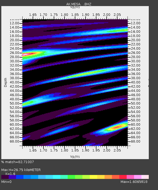
| Estimated Moho Depth: |
26.75 km |
| Estimated Crust Vp/Vs: |
1.60 |
| Assumed Crust Vp: |
6.566 km/s |
| Estimated Crust Vs: |
4.104 km/s |
| Estimated Crust Poisson's Ratio: |
0.18 |
|
| Radial Match: |
82.71007 % |
| Radial Bump: |
400 |
| Transverse Match: |
58.1193 % |
| Transverse Bump: |
400 |
| SOD ConfigId: |
512894 |
| Insert Time: |
2013-09-15 04:38:32.870 +0000 |
| GWidth: |
2.5 |
| Max Bumps: |
400 |
| Tol: |
0.001 |
|

Signal To Noise
| Channel | StoN | STA | LTA |
| AK:MESA: :BHZ:20130615T17:44:20.047976Z | 10.488621 | 1.28089E-6 | 1.2212188E-7 |
| AK:MESA: :BHN:20130615T17:44:20.047976Z | 1.6935396 | 2.7219522E-7 | 1.6072563E-7 |
| AK:MESA: :BHE:20130615T17:44:20.047976Z | 2.263085 | 4.964018E-7 | 2.193474E-7 |
| Arrivals |
| Ps | 2.6 SECOND |
| PpPs | 10 SECOND |
| PsPs/PpSs | 13 SECOND |


