You are here: Home > Network List > GS - US Geological Survey Networks Stations List
> Station DEC09 Decatur Surface Seismic Site, Decatur, IL, USA > Earthquake Result Viewer
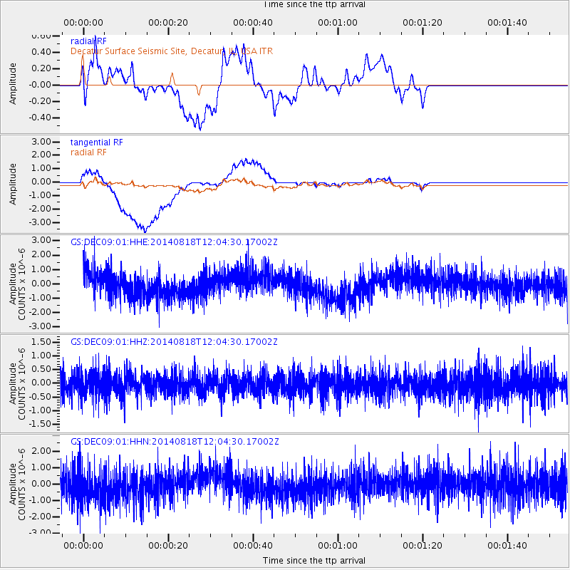
DEC09 Decatur Surface Seismic Site, Decatur, IL, USA - Earthquake Result Viewer
*The percent match for this event was below the threshold and hence no stack was calculated.
| Earthquake location: |
Iran-Iraq Border Region |
| Earthquake latitude/longitude: |
32.2/47.4 |
| Earthquake time(UTC): |
2014/08/18 (230) 11:51:30 GMT |
| Earthquake Depth: |
33 km |
| Earthquake Magnitude: |
5.4 MW, 5.7 mb |
| Earthquake Catalog/Contributor: |
ISC/ISC |
|
| Network: |
GS US Geological Survey Networks |
| Station: |
DEC09 Decatur Surface Seismic Site, Decatur, IL, USA |
| Lat/Lon: |
39.87 N/88.92 W |
| Elevation: |
207 m |
|
| Distance: |
97.7 deg |
| Az: |
327.573 deg |
| Baz: |
36.209 deg |
| Ray Param: |
$rayparam |
*The percent match for this event was below the threshold and hence was not used in the summary stack. |
|
| Radial Match: |
51.23482 % |
| Radial Bump: |
400 |
| Transverse Match: |
38.552513 % |
| Transverse Bump: |
400 |
| SOD ConfigId: |
3390531 |
| Insert Time: |
2019-04-13 10:48:27.888 +0000 |
| GWidth: |
2.5 |
| Max Bumps: |
400 |
| Tol: |
0.001 |
|
Signal To Noise
| Channel | StoN | STA | LTA |
| GS:DEC09:01:HHZ:20140818T12:04:30.17002Z | 1.1643828 | 4.8095274E-7 | 4.130538E-7 |
| GS:DEC09:01:HHN:20140818T12:04:30.17002Z | 1.1061261 | 1.0980888E-6 | 9.927338E-7 |
| GS:DEC09:01:HHE:20140818T12:04:30.17002Z | 0.8882928 | 7.7182045E-7 | 8.688807E-7 |
| Arrivals |
| Ps | |
| PpPs | |
| PsPs/PpSs | |


