You are here: Home > Network List > CC - Cascade Chain Volcano Monitoring Stations List
> Station PANH Panhandle Gap, Mt. Rainier, WA > Earthquake Result Viewer
PANH Panhandle Gap, Mt. Rainier, WA - Earthquake Result Viewer
| Earthquake location: |
Near Coast Of Nicaragua |
| Earthquake latitude/longitude: |
11.8/-86.9 |
| Earthquake time(UTC): |
2013/06/15 (166) 17:34:27 GMT |
| Earthquake Depth: |
30 km |
| Earthquake Magnitude: |
6.5 MW, 6.1 MB, 6.3 MS, 6.5 MW |
| Earthquake Catalog/Contributor: |
NEIC PDE/NEIC PDE-W |
|
| Network: |
CC Cascade Chain Volcano Monitoring |
| Station: |
PANH Panhandle Gap, Mt. Rainier, WA |
| Lat/Lon: |
46.86 N/121.64 W |
| Elevation: |
2109 m |
|
| Distance: |
45.6 deg |
| Az: |
326.835 deg |
| Baz: |
128.68 deg |
| Ray Param: |
0.07111567 |
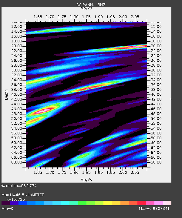
| Estimated Moho Depth: |
46.5 km |
| Estimated Crust Vp/Vs: |
1.67 |
| Assumed Crust Vp: |
6.597 km/s |
| Estimated Crust Vs: |
3.945 km/s |
| Estimated Crust Poisson's Ratio: |
0.22 |
|
| Radial Match: |
85.1774 % |
| Radial Bump: |
400 |
| Transverse Match: |
73.661316 % |
| Transverse Bump: |
400 |
| SOD ConfigId: |
512894 |
| Insert Time: |
2013-09-15 04:43:16.317 +0000 |
| GWidth: |
2.5 |
| Max Bumps: |
400 |
| Tol: |
0.001 |
|

Signal To Noise
| Channel | StoN | STA | LTA |
| CC:PANH: :BHZ:20130615T17:42:14.540011Z | 9.061263 | 1.3723148E-6 | 1.5144852E-7 |
| CC:PANH: :BHN:20130615T17:42:14.540011Z | 6.737817 | 4.7942046E-7 | 7.115368E-8 |
| CC:PANH: :BHE:20130615T17:42:14.540011Z | 3.379159 | 7.333207E-7 | 2.170128E-7 |
| Arrivals |
| Ps | 5.1 SECOND |
| PpPs | 18 SECOND |
| PsPs/PpSs | 23 SECOND |


