You are here: Home > Network List > CN - Canadian National Seismograph Network Stations List
> Station ATKO ATIKOKAN IRON MINE, ON > Earthquake Result Viewer
ATKO ATIKOKAN IRON MINE, ON - Earthquake Result Viewer
| Earthquake location: |
Near Coast Of Nicaragua |
| Earthquake latitude/longitude: |
11.8/-86.9 |
| Earthquake time(UTC): |
2013/06/15 (166) 17:34:27 GMT |
| Earthquake Depth: |
30 km |
| Earthquake Magnitude: |
6.5 MW, 6.1 MB, 6.3 MS, 6.5 MW |
| Earthquake Catalog/Contributor: |
NEIC PDE/NEIC PDE-W |
|
| Network: |
CN Canadian National Seismograph Network |
| Station: |
ATKO ATIKOKAN IRON MINE, ON |
| Lat/Lon: |
48.82 N/91.60 W |
| Elevation: |
383 m |
|
| Distance: |
37.2 deg |
| Az: |
354.883 deg |
| Baz: |
172.406 deg |
| Ray Param: |
0.07623996 |
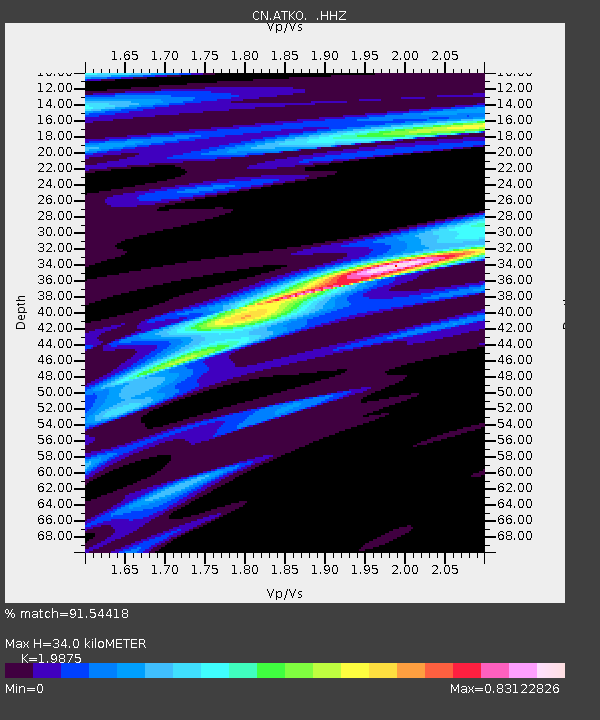
| Estimated Moho Depth: |
34.0 km |
| Estimated Crust Vp/Vs: |
1.99 |
| Assumed Crust Vp: |
6.467 km/s |
| Estimated Crust Vs: |
3.254 km/s |
| Estimated Crust Poisson's Ratio: |
0.33 |
|
| Radial Match: |
91.54418 % |
| Radial Bump: |
184 |
| Transverse Match: |
74.427925 % |
| Transverse Bump: |
400 |
| SOD ConfigId: |
512894 |
| Insert Time: |
2013-09-15 04:45:44.271 +0000 |
| GWidth: |
2.5 |
| Max Bumps: |
400 |
| Tol: |
0.001 |
|

Signal To Noise
| Channel | StoN | STA | LTA |
| CN:ATKO: :HHZ:20130615T17:41:05.380007Z | 31.698513 | 1.0898452E-6 | 3.438159E-8 |
| CN:ATKO: :HHN:20130615T17:41:05.380007Z | 12.81137 | 5.749142E-7 | 4.487531E-8 |
| CN:ATKO: :HHE:20130615T17:41:05.380007Z | 2.96143 | 1.700838E-7 | 5.7432995E-8 |
| Arrivals |
| Ps | 5.5 SECOND |
| PpPs | 15 SECOND |
| PsPs/PpSs | 20 SECOND |


