You are here: Home > Network List > CN - Canadian National Seismograph Network Stations List
> Station VIMO VICTOR MINE, ON > Earthquake Result Viewer
VIMO VICTOR MINE, ON - Earthquake Result Viewer
| Earthquake location: |
Near Coast Of Nicaragua |
| Earthquake latitude/longitude: |
11.8/-86.9 |
| Earthquake time(UTC): |
2013/06/15 (166) 17:34:27 GMT |
| Earthquake Depth: |
30 km |
| Earthquake Magnitude: |
6.5 MW, 6.1 MB, 6.3 MS, 6.5 MW |
| Earthquake Catalog/Contributor: |
NEIC PDE/NEIC PDE-W |
|
| Network: |
CN Canadian National Seismograph Network |
| Station: |
VIMO VICTOR MINE, ON |
| Lat/Lon: |
52.82 N/83.74 W |
| Elevation: |
78 m |
|
| Distance: |
41.0 deg |
| Az: |
2.941 deg |
| Baz: |
184.749 deg |
| Ray Param: |
0.07399248 |
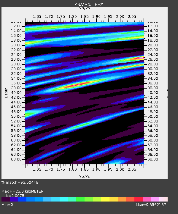
| Estimated Moho Depth: |
25.0 km |
| Estimated Crust Vp/Vs: |
2.10 |
| Assumed Crust Vp: |
6.459 km/s |
| Estimated Crust Vs: |
3.08 km/s |
| Estimated Crust Poisson's Ratio: |
0.35 |
|
| Radial Match: |
93.50448 % |
| Radial Bump: |
180 |
| Transverse Match: |
67.52555 % |
| Transverse Bump: |
400 |
| SOD ConfigId: |
512894 |
| Insert Time: |
2013-09-15 04:47:19.076 +0000 |
| GWidth: |
2.5 |
| Max Bumps: |
400 |
| Tol: |
0.001 |
|

Signal To Noise
| Channel | StoN | STA | LTA |
| CN:VIMO: :HHZ:20130615T17:41:37.709994Z | 17.435326 | 1.0792561E-6 | 6.190054E-8 |
| CN:VIMO: :HHN:20130615T17:41:37.709994Z | 10.011711 | 6.893091E-7 | 6.885028E-8 |
| CN:VIMO: :HHE:20130615T17:41:37.709994Z | 2.2807543 | 1.2459999E-7 | 5.4631045E-8 |
| Arrivals |
| Ps | 4.5 SECOND |
| PpPs | 11 SECOND |
| PsPs/PpSs | 16 SECOND |


