You are here: Home > Network List > LD - Lamont-Doherty Cooperative Seismographic Network Stations List
> Station BRNJ Basking Ridge, New Jersey > Earthquake Result Viewer
BRNJ Basking Ridge, New Jersey - Earthquake Result Viewer
| Earthquake location: |
Near Coast Of Nicaragua |
| Earthquake latitude/longitude: |
11.8/-86.9 |
| Earthquake time(UTC): |
2013/06/15 (166) 17:34:27 GMT |
| Earthquake Depth: |
30 km |
| Earthquake Magnitude: |
6.5 MW, 6.1 MB, 6.3 MS, 6.5 MW |
| Earthquake Catalog/Contributor: |
NEIC PDE/NEIC PDE-W |
|
| Network: |
LD Lamont-Doherty Cooperative Seismographic Network |
| Station: |
BRNJ Basking Ridge, New Jersey |
| Lat/Lon: |
40.68 N/74.57 W |
| Elevation: |
50 m |
|
| Distance: |
30.8 deg |
| Az: |
18.539 deg |
| Baz: |
204.168 deg |
| Ray Param: |
0.07921133 |
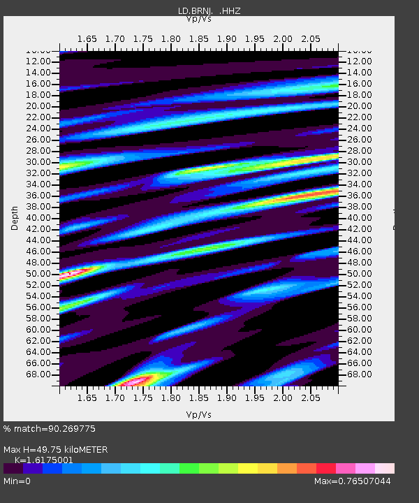
| Estimated Moho Depth: |
49.75 km |
| Estimated Crust Vp/Vs: |
1.62 |
| Assumed Crust Vp: |
6.283 km/s |
| Estimated Crust Vs: |
3.885 km/s |
| Estimated Crust Poisson's Ratio: |
0.19 |
|
| Radial Match: |
90.269775 % |
| Radial Bump: |
355 |
| Transverse Match: |
68.66919 % |
| Transverse Bump: |
400 |
| SOD ConfigId: |
512894 |
| Insert Time: |
2013-09-15 04:53:07.829 +0000 |
| GWidth: |
2.5 |
| Max Bumps: |
400 |
| Tol: |
0.001 |
|
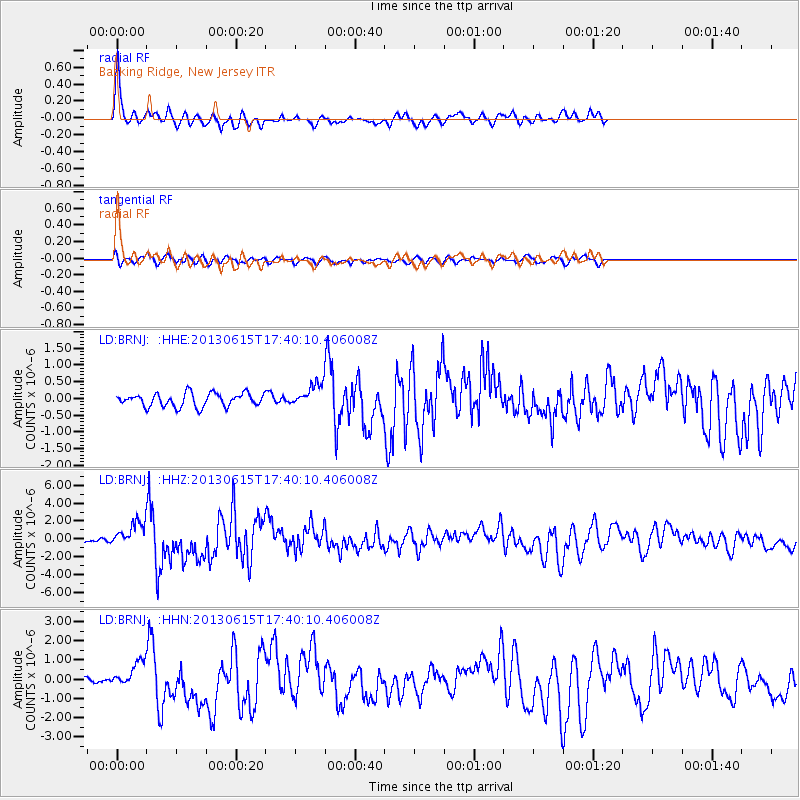
Signal To Noise
| Channel | StoN | STA | LTA |
| LD:BRNJ: :HHZ:20130615T17:40:10.406008Z | 6.1351995 | 1.355128E-6 | 2.2087757E-7 |
| LD:BRNJ: :HHN:20130615T17:40:10.406008Z | 2.3219974 | 6.28333E-7 | 2.7060022E-7 |
| LD:BRNJ: :HHE:20130615T17:40:10.406008Z | 1.6488485 | 3.2522996E-7 | 1.9724673E-7 |
| Arrivals |
| Ps | 5.3 SECOND |
| PpPs | 19 SECOND |
| PsPs/PpSs | 24 SECOND |


