You are here: Home > Network List > NE - New England Seismic Network Stations List
> Station TRY Troy, NY, USA > Earthquake Result Viewer
TRY Troy, NY, USA - Earthquake Result Viewer
| Earthquake location: |
Near Coast Of Nicaragua |
| Earthquake latitude/longitude: |
11.8/-86.9 |
| Earthquake time(UTC): |
2013/06/15 (166) 17:34:27 GMT |
| Earthquake Depth: |
30 km |
| Earthquake Magnitude: |
6.5 MW, 6.1 MB, 6.3 MS, 6.5 MW |
| Earthquake Catalog/Contributor: |
NEIC PDE/NEIC PDE-W |
|
| Network: |
NE New England Seismic Network |
| Station: |
TRY Troy, NY, USA |
| Lat/Lon: |
42.73 N/73.67 W |
| Elevation: |
89 m |
|
| Distance: |
32.9 deg |
| Az: |
18.108 deg |
| Baz: |
204.398 deg |
| Ray Param: |
0.07839218 |
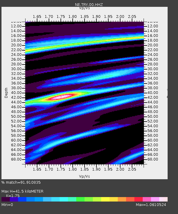
| Estimated Moho Depth: |
41.5 km |
| Estimated Crust Vp/Vs: |
1.75 |
| Assumed Crust Vp: |
6.419 km/s |
| Estimated Crust Vs: |
3.668 km/s |
| Estimated Crust Poisson's Ratio: |
0.26 |
|
| Radial Match: |
91.910835 % |
| Radial Bump: |
253 |
| Transverse Match: |
78.06007 % |
| Transverse Bump: |
400 |
| SOD ConfigId: |
512894 |
| Insert Time: |
2013-09-15 04:55:33.155 +0000 |
| GWidth: |
2.5 |
| Max Bumps: |
400 |
| Tol: |
0.001 |
|

Signal To Noise
| Channel | StoN | STA | LTA |
| NE:TRY:00:HHZ:20130615T17:40:29.183993Z | 6.735757 | 1.3402121E-6 | 1.9896979E-7 |
| NE:TRY:00:HH1:20130615T17:40:29.183993Z | 4.2208776 | 8.6458596E-7 | 2.0483559E-7 |
| NE:TRY:00:HH2:20130615T17:40:29.183993Z | 2.2067676 | 5.412447E-7 | 2.4526585E-7 |
| Arrivals |
| Ps | 5.2 SECOND |
| PpPs | 16 SECOND |
| PsPs/PpSs | 22 SECOND |


