You are here: Home > Network List > TA - USArray Transportable Network (new EarthScope stations) Stations List
> Station D62A Allapoint, Allagash, ME, USA > Earthquake Result Viewer
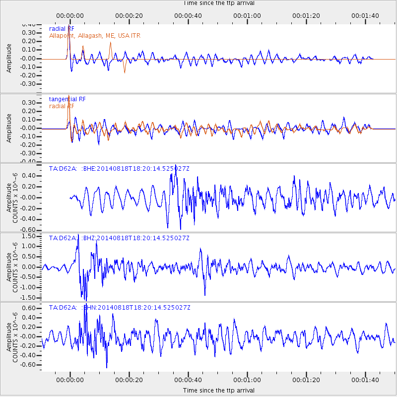
D62A Allapoint, Allagash, ME, USA - Earthquake Result Viewer
*The percent match for this event was below the threshold and hence no stack was calculated.
| Earthquake location: |
Iran-Iraq Border Region |
| Earthquake latitude/longitude: |
32.6/47.7 |
| Earthquake time(UTC): |
2014/08/18 (230) 18:08:23 GMT |
| Earthquake Depth: |
10 km |
| Earthquake Magnitude: |
5.7 MWB |
| Earthquake Catalog/Contributor: |
NEIC PDE/NEIC COMCAT |
|
| Network: |
TA USArray Transportable Network (new EarthScope stations) |
| Station: |
D62A Allapoint, Allagash, ME, USA |
| Lat/Lon: |
47.08 N/69.05 W |
| Elevation: |
189 m |
|
| Distance: |
82.5 deg |
| Az: |
322.005 deg |
| Baz: |
49.528 deg |
| Ray Param: |
$rayparam |
*The percent match for this event was below the threshold and hence was not used in the summary stack. |
|
| Radial Match: |
56.157864 % |
| Radial Bump: |
368 |
| Transverse Match: |
61.054855 % |
| Transverse Bump: |
400 |
| SOD ConfigId: |
3390531 |
| Insert Time: |
2019-04-13 10:55:11.284 +0000 |
| GWidth: |
2.5 |
| Max Bumps: |
400 |
| Tol: |
0.001 |
|
Signal To Noise
| Channel | StoN | STA | LTA |
| TA:D62A: :BHZ:20140818T18:20:14.525027Z | 6.302411 | 7.204487E-7 | 1.14313195E-7 |
| TA:D62A: :BHN:20140818T18:20:14.525027Z | 1.4820051 | 1.8287506E-7 | 1.2339704E-7 |
| TA:D62A: :BHE:20140818T18:20:14.525027Z | 1.8428626 | 2.3122828E-7 | 1.2547235E-7 |
| Arrivals |
| Ps | |
| PpPs | |
| PsPs/PpSs | |


