You are here: Home > Network List > TA - USArray Transportable Network (new EarthScope stations) Stations List
> Station Q56A Snyder Ridge, Maysville, WV, USA > Earthquake Result Viewer
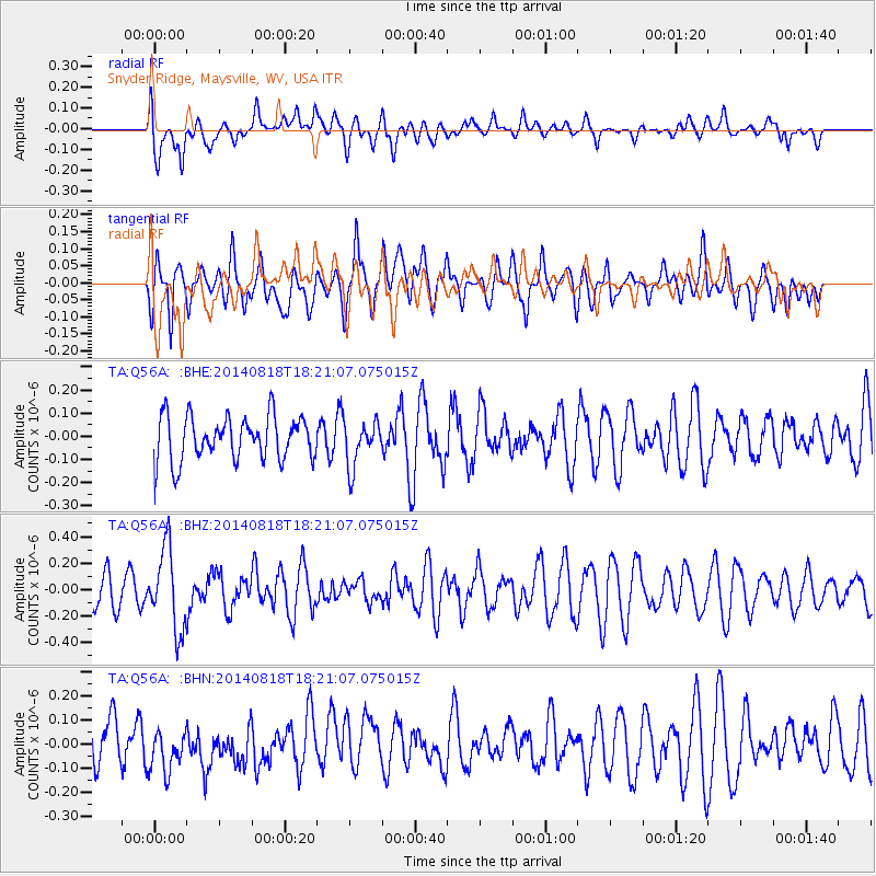
Q56A Snyder Ridge, Maysville, WV, USA - Earthquake Result Viewer
*The percent match for this event was below the threshold and hence no stack was calculated.
| Earthquake location: |
Iran-Iraq Border Region |
| Earthquake latitude/longitude: |
32.6/47.7 |
| Earthquake time(UTC): |
2014/08/18 (230) 18:08:23 GMT |
| Earthquake Depth: |
10 km |
| Earthquake Magnitude: |
5.7 MWB |
| Earthquake Catalog/Contributor: |
NEIC PDE/NEIC COMCAT |
|
| Network: |
TA USArray Transportable Network (new EarthScope stations) |
| Station: |
Q56A Snyder Ridge, Maysville, WV, USA |
| Lat/Lon: |
39.04 N/79.19 W |
| Elevation: |
430 m |
|
| Distance: |
93.4 deg |
| Az: |
321.394 deg |
| Baz: |
42.582 deg |
| Ray Param: |
$rayparam |
*The percent match for this event was below the threshold and hence was not used in the summary stack. |
|
| Radial Match: |
60.436954 % |
| Radial Bump: |
400 |
| Transverse Match: |
48.89098 % |
| Transverse Bump: |
400 |
| SOD ConfigId: |
3390531 |
| Insert Time: |
2019-04-13 10:55:37.375 +0000 |
| GWidth: |
2.5 |
| Max Bumps: |
400 |
| Tol: |
0.001 |
|
Signal To Noise
| Channel | StoN | STA | LTA |
| TA:Q56A: :BHZ:20140818T18:21:07.075015Z | 2.4770832 | 3.0350176E-7 | 1.2252384E-7 |
| TA:Q56A: :BHN:20140818T18:21:07.075015Z | 0.7327552 | 9.1483194E-8 | 1.2484824E-7 |
| TA:Q56A: :BHE:20140818T18:21:07.075015Z | 1.0341583 | 9.573455E-8 | 9.257243E-8 |
| Arrivals |
| Ps | |
| PpPs | |
| PsPs/PpSs | |


