You are here: Home > Network List > PO - Portable Observatories for Lithospheric Analysis and Research Investigating Seis Stations List
> Station PEMO PEMBROKE, ON > Earthquake Result Viewer
PEMO PEMBROKE, ON - Earthquake Result Viewer
| Earthquake location: |
Near Coast Of Nicaragua |
| Earthquake latitude/longitude: |
11.8/-86.9 |
| Earthquake time(UTC): |
2013/06/15 (166) 17:34:27 GMT |
| Earthquake Depth: |
30 km |
| Earthquake Magnitude: |
6.5 MW, 6.1 MB, 6.3 MS, 6.5 MW |
| Earthquake Catalog/Contributor: |
NEIC PDE/NEIC PDE-W |
|
| Network: |
PO Portable Observatories for Lithospheric Analysis and Research Investigating Seis |
| Station: |
PEMO PEMBROKE, ON |
| Lat/Lon: |
45.68 N/77.25 W |
| Elevation: |
180 m |
|
| Distance: |
34.8 deg |
| Az: |
11.922 deg |
| Baz: |
196.771 deg |
| Ray Param: |
0.07750756 |
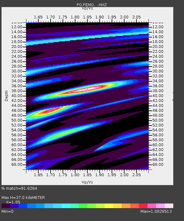
| Estimated Moho Depth: |
37.0 km |
| Estimated Crust Vp/Vs: |
1.85 |
| Assumed Crust Vp: |
6.577 km/s |
| Estimated Crust Vs: |
3.555 km/s |
| Estimated Crust Poisson's Ratio: |
0.29 |
|
| Radial Match: |
91.8284 % |
| Radial Bump: |
235 |
| Transverse Match: |
51.400623 % |
| Transverse Bump: |
400 |
| SOD ConfigId: |
512894 |
| Insert Time: |
2013-09-15 04:59:44.851 +0000 |
| GWidth: |
2.5 |
| Max Bumps: |
400 |
| Tol: |
0.001 |
|

Signal To Noise
| Channel | StoN | STA | LTA |
| PO:PEMO: :HHZ:20130615T17:40:45.230013Z | 12.118639 | 7.876462E-7 | 6.499461E-8 |
| PO:PEMO: :HHN:20130615T17:40:45.230013Z | 8.331978 | 4.592408E-7 | 5.5117862E-8 |
| PO:PEMO: :HHE:20130615T17:40:45.230013Z | 1.9573352 | 1.5285144E-7 | 7.80916E-8 |
| Arrivals |
| Ps | 5.2 SECOND |
| PpPs | 15 SECOND |
| PsPs/PpSs | 20 SECOND |


