You are here: Home > Network List > PO - Portable Observatories for Lithospheric Analysis and Research Investigating Seis Stations List
> Station PLIO PELEE ISLAND, ON > Earthquake Result Viewer
PLIO PELEE ISLAND, ON - Earthquake Result Viewer
| Earthquake location: |
Near Coast Of Nicaragua |
| Earthquake latitude/longitude: |
11.8/-86.9 |
| Earthquake time(UTC): |
2013/06/15 (166) 17:34:27 GMT |
| Earthquake Depth: |
30 km |
| Earthquake Magnitude: |
6.5 MW, 6.1 MB, 6.3 MS, 6.5 MW |
| Earthquake Catalog/Contributor: |
NEIC PDE/NEIC PDE-W |
|
| Network: |
PO Portable Observatories for Lithospheric Analysis and Research Investigating Seis |
| Station: |
PLIO PELEE ISLAND, ON |
| Lat/Lon: |
41.75 N/82.63 W |
| Elevation: |
143 m |
|
| Distance: |
30.1 deg |
| Az: |
6.418 deg |
| Baz: |
188.412 deg |
| Ray Param: |
0.079391785 |
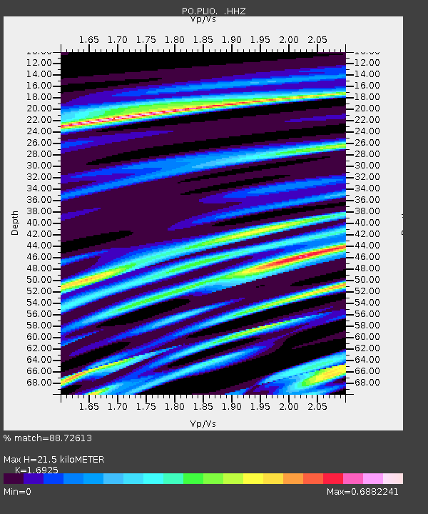
| Estimated Moho Depth: |
21.5 km |
| Estimated Crust Vp/Vs: |
1.69 |
| Assumed Crust Vp: |
6.498 km/s |
| Estimated Crust Vs: |
3.839 km/s |
| Estimated Crust Poisson's Ratio: |
0.23 |
|
| Radial Match: |
88.72613 % |
| Radial Bump: |
333 |
| Transverse Match: |
62.08429 % |
| Transverse Bump: |
400 |
| SOD ConfigId: |
512894 |
| Insert Time: |
2013-09-15 04:59:51.769 +0000 |
| GWidth: |
2.5 |
| Max Bumps: |
400 |
| Tol: |
0.001 |
|

Signal To Noise
| Channel | StoN | STA | LTA |
| PO:PLIO: :HHZ:20130615T17:40:04.350009Z | 15.300074 | 8.891268E-7 | 5.8112583E-8 |
| PO:PLIO: :HHN:20130615T17:40:04.350009Z | 8.058021 | 5.3250943E-7 | 6.6084404E-8 |
| PO:PLIO: :HHE:20130615T17:40:04.350009Z | 1.753234 | 1.0706795E-7 | 6.106883E-8 |
| Arrivals |
| Ps | 2.5 SECOND |
| PpPs | 8.2 SECOND |
| PsPs/PpSs | 11 SECOND |


