You are here: Home > Network List > TA - USArray Transportable Network (new EarthScope stations) Stations List
> Station D03D Eldon, WA, USA > Earthquake Result Viewer
D03D Eldon, WA, USA - Earthquake Result Viewer
| Earthquake location: |
Near Coast Of Nicaragua |
| Earthquake latitude/longitude: |
11.8/-86.9 |
| Earthquake time(UTC): |
2013/06/15 (166) 17:34:27 GMT |
| Earthquake Depth: |
30 km |
| Earthquake Magnitude: |
6.5 MW, 6.1 MB, 6.3 MS, 6.5 MW |
| Earthquake Catalog/Contributor: |
NEIC PDE/NEIC PDE-W |
|
| Network: |
TA USArray Transportable Network (new EarthScope stations) |
| Station: |
D03D Eldon, WA, USA |
| Lat/Lon: |
47.53 N/123.09 W |
| Elevation: |
262 m |
|
| Distance: |
46.8 deg |
| Az: |
326.728 deg |
| Baz: |
127.548 deg |
| Ray Param: |
0.07036391 |
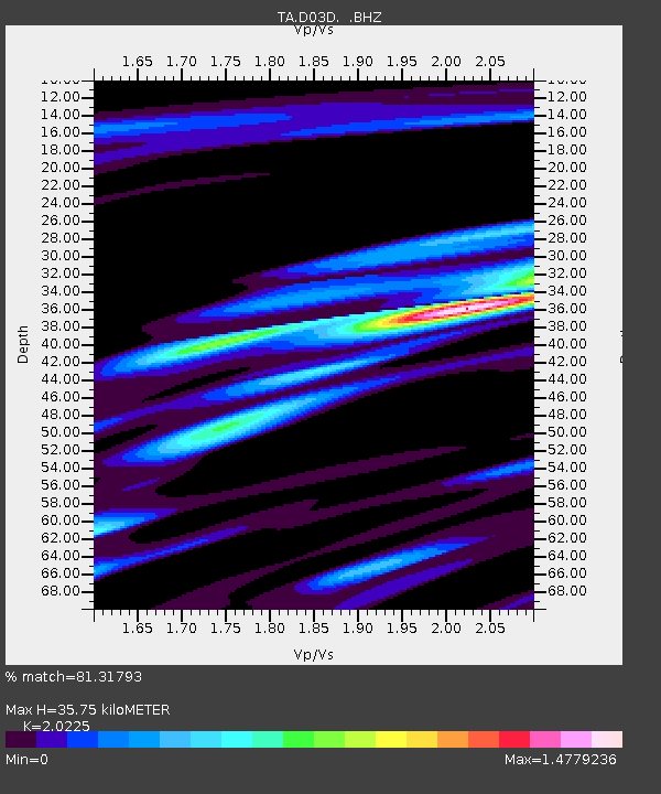
| Estimated Moho Depth: |
35.75 km |
| Estimated Crust Vp/Vs: |
2.02 |
| Assumed Crust Vp: |
6.566 km/s |
| Estimated Crust Vs: |
3.247 km/s |
| Estimated Crust Poisson's Ratio: |
0.34 |
|
| Radial Match: |
81.31793 % |
| Radial Bump: |
400 |
| Transverse Match: |
59.522747 % |
| Transverse Bump: |
400 |
| SOD ConfigId: |
512894 |
| Insert Time: |
2013-09-15 05:01:51.903 +0000 |
| GWidth: |
2.5 |
| Max Bumps: |
400 |
| Tol: |
0.001 |
|

Signal To Noise
| Channel | StoN | STA | LTA |
| TA:D03D: :BHZ:20130615T17:42:23.899996Z | 11.950594 | 1.2406355E-6 | 1.0381371E-7 |
| TA:D03D: :BHN:20130615T17:42:23.899996Z | 5.902568 | 5.3005243E-7 | 8.980032E-8 |
| TA:D03D: :BHE:20130615T17:42:23.899996Z | 15.164644 | 6.504314E-7 | 4.2891305E-8 |
| Arrivals |
| Ps | 5.9 SECOND |
| PpPs | 16 SECOND |
| PsPs/PpSs | 21 SECOND |


