You are here: Home > Network List > TA - USArray Transportable Network (new EarthScope stations) Stations List
> Station D46A Sault St. Marie, ON, CAN > Earthquake Result Viewer
D46A Sault St. Marie, ON, CAN - Earthquake Result Viewer
| Earthquake location: |
Near Coast Of Nicaragua |
| Earthquake latitude/longitude: |
11.8/-86.9 |
| Earthquake time(UTC): |
2013/06/15 (166) 17:34:27 GMT |
| Earthquake Depth: |
30 km |
| Earthquake Magnitude: |
6.5 MW, 6.1 MB, 6.3 MS, 6.5 MW |
| Earthquake Catalog/Contributor: |
NEIC PDE/NEIC PDE-W |
|
| Network: |
TA USArray Transportable Network (new EarthScope stations) |
| Station: |
D46A Sault St. Marie, ON, CAN |
| Lat/Lon: |
46.89 N/84.04 W |
| Elevation: |
353 m |
|
| Distance: |
35.1 deg |
| Az: |
3.448 deg |
| Baz: |
184.927 deg |
| Ray Param: |
0.077349804 |
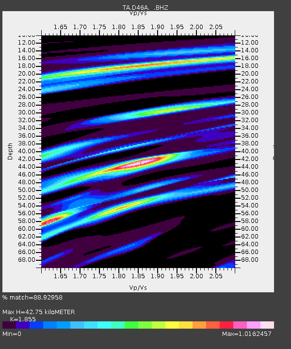
| Estimated Moho Depth: |
42.75 km |
| Estimated Crust Vp/Vs: |
1.86 |
| Assumed Crust Vp: |
6.467 km/s |
| Estimated Crust Vs: |
3.486 km/s |
| Estimated Crust Poisson's Ratio: |
0.30 |
|
| Radial Match: |
88.92958 % |
| Radial Bump: |
192 |
| Transverse Match: |
67.56969 % |
| Transverse Bump: |
400 |
| SOD ConfigId: |
512894 |
| Insert Time: |
2013-09-15 05:01:56.498 +0000 |
| GWidth: |
2.5 |
| Max Bumps: |
400 |
| Tol: |
0.001 |
|

Signal To Noise
| Channel | StoN | STA | LTA |
| TA:D46A: :BHZ:20130615T17:40:47.875002Z | 13.11448 | 2.0265386E-6 | 1.5452679E-7 |
| TA:D46A: :BHN:20130615T17:40:47.875002Z | 8.35681 | 1.4510973E-6 | 1.7364249E-7 |
| TA:D46A: :BHE:20130615T17:40:47.875002Z | 2.1514285 | 2.2701202E-7 | 1.0551688E-7 |
| Arrivals |
| Ps | 6.1 SECOND |
| PpPs | 18 SECOND |
| PsPs/PpSs | 24 SECOND |


