You are here: Home > Network List > XJ13 - CRAFTI Stations List
> Station LL21 Loliondo SS > Earthquake Result Viewer
LL21 Loliondo SS - Earthquake Result Viewer
| Earthquake location: |
Iran-Iraq Border Region |
| Earthquake latitude/longitude: |
32.6/47.7 |
| Earthquake time(UTC): |
2014/08/18 (230) 18:08:23 GMT |
| Earthquake Depth: |
10 km |
| Earthquake Magnitude: |
5.7 MWB |
| Earthquake Catalog/Contributor: |
NEIC PDE/NEIC COMCAT |
|
| Network: |
XJ CRAFTI |
| Station: |
LL21 Loliondo SS |
| Lat/Lon: |
2.06 S/35.55 E |
| Elevation: |
2040 m |
|
| Distance: |
36.3 deg |
| Az: |
200.806 deg |
| Baz: |
17.468 deg |
| Ray Param: |
0.07675609 |
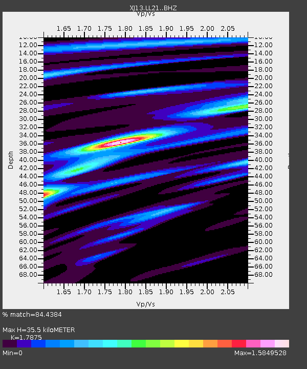
| Estimated Moho Depth: |
35.5 km |
| Estimated Crust Vp/Vs: |
1.79 |
| Assumed Crust Vp: |
6.576 km/s |
| Estimated Crust Vs: |
3.679 km/s |
| Estimated Crust Poisson's Ratio: |
0.27 |
|
| Radial Match: |
84.4384 % |
| Radial Bump: |
317 |
| Transverse Match: |
63.695045 % |
| Transverse Bump: |
400 |
| SOD ConfigId: |
3390531 |
| Insert Time: |
2019-04-13 10:56:28.980 +0000 |
| GWidth: |
2.5 |
| Max Bumps: |
400 |
| Tol: |
0.001 |
|

Signal To Noise
| Channel | StoN | STA | LTA |
| XJ:LL21: :BHZ:20140818T18:14:56.600009Z | 3.6602674 | 2.1160342E-7 | 5.7810922E-8 |
| XJ:LL21: :BHN:20140818T18:14:56.600009Z | 1.3872361 | 1.3813406E-7 | 9.957501E-8 |
| XJ:LL21: :BHE:20140818T18:14:56.600009Z | 2.898432 | 2.186352E-7 | 7.543223E-8 |
| Arrivals |
| Ps | 4.6 SECOND |
| PpPs | 14 SECOND |
| PsPs/PpSs | 19 SECOND |


