You are here: Home > Network List > TA - USArray Transportable Network (new EarthScope stations) Stations List
> Station D49A Beulah Township, ON, CAN > Earthquake Result Viewer
D49A Beulah Township, ON, CAN - Earthquake Result Viewer
| Earthquake location: |
Near Coast Of Nicaragua |
| Earthquake latitude/longitude: |
11.8/-86.9 |
| Earthquake time(UTC): |
2013/06/15 (166) 17:34:27 GMT |
| Earthquake Depth: |
30 km |
| Earthquake Magnitude: |
6.5 MW, 6.1 MB, 6.3 MS, 6.5 MW |
| Earthquake Catalog/Contributor: |
NEIC PDE/NEIC PDE-W |
|
| Network: |
TA USArray Transportable Network (new EarthScope stations) |
| Station: |
D49A Beulah Township, ON, CAN |
| Lat/Lon: |
47.27 N/81.36 W |
| Elevation: |
416 m |
|
| Distance: |
35.7 deg |
| Az: |
6.503 deg |
| Baz: |
189.373 deg |
| Ray Param: |
0.07702698 |
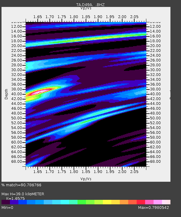
| Estimated Moho Depth: |
39.0 km |
| Estimated Crust Vp/Vs: |
1.66 |
| Assumed Crust Vp: |
6.467 km/s |
| Estimated Crust Vs: |
3.901 km/s |
| Estimated Crust Poisson's Ratio: |
0.21 |
|
| Radial Match: |
90.786766 % |
| Radial Bump: |
259 |
| Transverse Match: |
75.244576 % |
| Transverse Bump: |
400 |
| SOD ConfigId: |
512894 |
| Insert Time: |
2013-09-15 05:02:09.589 +0000 |
| GWidth: |
2.5 |
| Max Bumps: |
400 |
| Tol: |
0.001 |
|

Signal To Noise
| Channel | StoN | STA | LTA |
| TA:D49A: :BHZ:20130615T17:40:53.075015Z | 21.365442 | 2.9353932E-6 | 1.3738978E-7 |
| TA:D49A: :BHN:20130615T17:40:53.075015Z | 10.069872 | 2.2168922E-6 | 2.20151E-7 |
| TA:D49A: :BHE:20130615T17:40:53.075015Z | 4.6515703 | 6.256975E-7 | 1.3451319E-7 |
| Arrivals |
| Ps | 4.3 SECOND |
| PpPs | 15 SECOND |
| PsPs/PpSs | 19 SECOND |


