You are here: Home > Network List > XJ13 - CRAFTI Stations List
> Station LN14 Matela PS > Earthquake Result Viewer
LN14 Matela PS - Earthquake Result Viewer
| Earthquake location: |
Iran-Iraq Border Region |
| Earthquake latitude/longitude: |
32.6/47.7 |
| Earthquake time(UTC): |
2014/08/18 (230) 18:08:23 GMT |
| Earthquake Depth: |
10 km |
| Earthquake Magnitude: |
5.7 MWB |
| Earthquake Catalog/Contributor: |
NEIC PDE/NEIC COMCAT |
|
| Network: |
XJ CRAFTI |
| Station: |
LN14 Matela PS |
| Lat/Lon: |
2.44 S/36.42 E |
| Elevation: |
1631 m |
|
| Distance: |
36.4 deg |
| Az: |
199.229 deg |
| Baz: |
16.164 deg |
| Ray Param: |
0.07669709 |
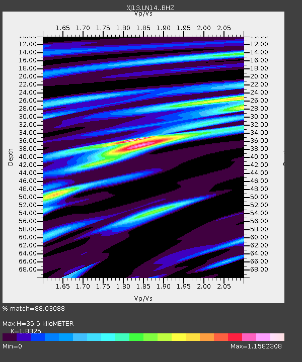
| Estimated Moho Depth: |
35.5 km |
| Estimated Crust Vp/Vs: |
1.83 |
| Assumed Crust Vp: |
6.601 km/s |
| Estimated Crust Vs: |
3.602 km/s |
| Estimated Crust Poisson's Ratio: |
0.29 |
|
| Radial Match: |
88.03088 % |
| Radial Bump: |
260 |
| Transverse Match: |
54.374878 % |
| Transverse Bump: |
400 |
| SOD ConfigId: |
3390531 |
| Insert Time: |
2019-04-13 10:56:32.056 +0000 |
| GWidth: |
2.5 |
| Max Bumps: |
400 |
| Tol: |
0.001 |
|

Signal To Noise
| Channel | StoN | STA | LTA |
| XJ:LN14: :BHZ:20140818T18:14:57.519991Z | 2.8535106 | 2.2018945E-7 | 7.716441E-8 |
| XJ:LN14: :BHN:20140818T18:14:57.519991Z | 1.9584395 | 1.4409454E-7 | 7.35762E-8 |
| XJ:LN14: :BHE:20140818T18:14:57.519991Z | 0.8545841 | 6.55153E-8 | 7.6663376E-8 |
| Arrivals |
| Ps | 4.8 SECOND |
| PpPs | 14 SECOND |
| PsPs/PpSs | 19 SECOND |


