You are here: Home > Network List > XJ13 - CRAFTI Stations List
> Station LN15 Lekule Girls' SS > Earthquake Result Viewer
LN15 Lekule Girls' SS - Earthquake Result Viewer
| Earthquake location: |
Iran-Iraq Border Region |
| Earthquake latitude/longitude: |
32.6/47.7 |
| Earthquake time(UTC): |
2014/08/18 (230) 18:08:23 GMT |
| Earthquake Depth: |
10 km |
| Earthquake Magnitude: |
5.7 MWB |
| Earthquake Catalog/Contributor: |
NEIC PDE/NEIC COMCAT |
|
| Network: |
XJ CRAFTI |
| Station: |
LN15 Lekule Girls' SS |
| Lat/Lon: |
2.63 S/36.18 E |
| Elevation: |
1327 m |
|
| Distance: |
36.7 deg |
| Az: |
199.512 deg |
| Baz: |
16.402 deg |
| Ray Param: |
0.07656396 |
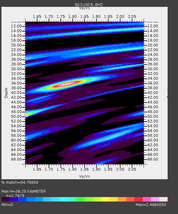
| Estimated Moho Depth: |
36.25 km |
| Estimated Crust Vp/Vs: |
1.77 |
| Assumed Crust Vp: |
6.601 km/s |
| Estimated Crust Vs: |
3.734 km/s |
| Estimated Crust Poisson's Ratio: |
0.26 |
|
| Radial Match: |
84.78854 % |
| Radial Bump: |
322 |
| Transverse Match: |
64.30876 % |
| Transverse Bump: |
400 |
| SOD ConfigId: |
3390531 |
| Insert Time: |
2019-04-13 10:56:32.731 +0000 |
| GWidth: |
2.5 |
| Max Bumps: |
400 |
| Tol: |
0.001 |
|

Signal To Noise
| Channel | StoN | STA | LTA |
| XJ:LN15: :BHZ:20140818T18:14:59.600009Z | 3.302536 | 3.163709E-7 | 9.5796345E-8 |
| XJ:LN15: :BHN:20140818T18:14:59.600009Z | 1.7143793 | 1.8510353E-7 | 1.0797117E-7 |
| XJ:LN15: :BHE:20140818T18:14:59.600009Z | 1.1300088 | 1.1502983E-7 | 1.0179551E-7 |
| Arrivals |
| Ps | 4.6 SECOND |
| PpPs | 14 SECOND |
| PsPs/PpSs | 19 SECOND |


