You are here: Home > Network List > TA - USArray Transportable Network (new EarthScope stations) Stations List
> Station E48A Lockeyer, ON, CAN > Earthquake Result Viewer
E48A Lockeyer, ON, CAN - Earthquake Result Viewer
| Earthquake location: |
Near Coast Of Nicaragua |
| Earthquake latitude/longitude: |
11.8/-86.9 |
| Earthquake time(UTC): |
2013/06/15 (166) 17:34:27 GMT |
| Earthquake Depth: |
30 km |
| Earthquake Magnitude: |
6.5 MW, 6.1 MB, 6.3 MS, 6.5 MW |
| Earthquake Catalog/Contributor: |
NEIC PDE/NEIC PDE-W |
|
| Network: |
TA USArray Transportable Network (new EarthScope stations) |
| Station: |
E48A Lockeyer, ON, CAN |
| Lat/Lon: |
46.48 N/82.17 W |
| Elevation: |
347 m |
|
| Distance: |
34.8 deg |
| Az: |
5.762 deg |
| Baz: |
188.18 deg |
| Ray Param: |
0.077484444 |
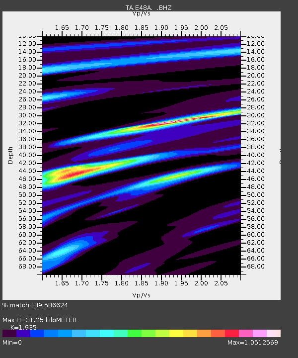
| Estimated Moho Depth: |
31.25 km |
| Estimated Crust Vp/Vs: |
1.93 |
| Assumed Crust Vp: |
6.467 km/s |
| Estimated Crust Vs: |
3.342 km/s |
| Estimated Crust Poisson's Ratio: |
0.32 |
|
| Radial Match: |
89.586624 % |
| Radial Bump: |
205 |
| Transverse Match: |
73.290344 % |
| Transverse Bump: |
400 |
| SOD ConfigId: |
512894 |
| Insert Time: |
2013-09-15 05:02:42.628 +0000 |
| GWidth: |
2.5 |
| Max Bumps: |
400 |
| Tol: |
0.001 |
|
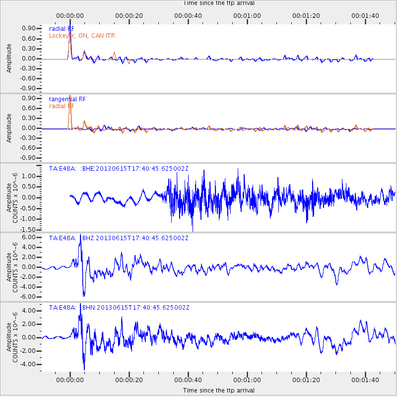
Signal To Noise
| Channel | StoN | STA | LTA |
| TA:E48A: :BHZ:20130615T17:40:45.625002Z | 16.987225 | 2.76753E-6 | 1.6291833E-7 |
| TA:E48A: :BHN:20130615T17:40:45.625002Z | 12.758231 | 1.993898E-6 | 1.5628328E-7 |
| TA:E48A: :BHE:20130615T17:40:45.625002Z | 2.124958 | 3.6590032E-7 | 1.7219179E-7 |
| Arrivals |
| Ps | 4.8 SECOND |
| PpPs | 13 SECOND |
| PsPs/PpSs | 18 SECOND |


