You are here: Home > Network List > XJ13 - CRAFTI Stations List
> Station LN34 Lwondulwo boma > Earthquake Result Viewer
LN34 Lwondulwo boma - Earthquake Result Viewer
| Earthquake location: |
Iran-Iraq Border Region |
| Earthquake latitude/longitude: |
32.6/47.7 |
| Earthquake time(UTC): |
2014/08/18 (230) 18:08:23 GMT |
| Earthquake Depth: |
10 km |
| Earthquake Magnitude: |
5.7 MWB |
| Earthquake Catalog/Contributor: |
NEIC PDE/NEIC COMCAT |
|
| Network: |
XJ CRAFTI |
| Station: |
LN34 Lwondulwo boma |
| Lat/Lon: |
2.75 S/36.05 E |
| Elevation: |
1066 m |
|
| Distance: |
36.8 deg |
| Az: |
199.672 deg |
| Baz: |
16.536 deg |
| Ray Param: |
0.076479085 |
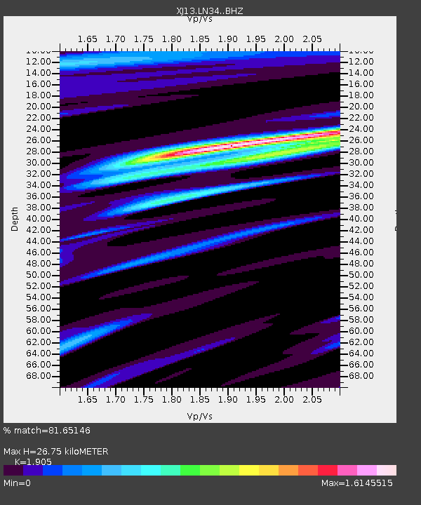
| Estimated Moho Depth: |
26.75 km |
| Estimated Crust Vp/Vs: |
1.90 |
| Assumed Crust Vp: |
6.601 km/s |
| Estimated Crust Vs: |
3.465 km/s |
| Estimated Crust Poisson's Ratio: |
0.31 |
|
| Radial Match: |
81.65146 % |
| Radial Bump: |
374 |
| Transverse Match: |
72.02671 % |
| Transverse Bump: |
400 |
| SOD ConfigId: |
3390531 |
| Insert Time: |
2019-04-13 10:56:34.544 +0000 |
| GWidth: |
2.5 |
| Max Bumps: |
400 |
| Tol: |
0.001 |
|

Signal To Noise
| Channel | StoN | STA | LTA |
| XJ:LN34: :BHZ:20140818T18:15:00.919985Z | 3.1643448 | 3.0791898E-7 | 9.730892E-8 |
| XJ:LN34: :BHN:20140818T18:15:00.919985Z | 2.059798 | 1.9998618E-7 | 9.7090194E-8 |
| XJ:LN34: :BHE:20140818T18:15:00.919985Z | 0.8270747 | 6.8433934E-8 | 8.274214E-8 |
| Arrivals |
| Ps | 3.9 SECOND |
| PpPs | 11 SECOND |
| PsPs/PpSs | 15 SECOND |


