You are here: Home > Network List > XJ13 - CRAFTI Stations List
> Station PR33 Engutoto Boma > Earthquake Result Viewer
PR33 Engutoto Boma - Earthquake Result Viewer
| Earthquake location: |
Iran-Iraq Border Region |
| Earthquake latitude/longitude: |
32.6/47.7 |
| Earthquake time(UTC): |
2014/08/18 (230) 18:08:23 GMT |
| Earthquake Depth: |
10 km |
| Earthquake Magnitude: |
5.7 MWB |
| Earthquake Catalog/Contributor: |
NEIC PDE/NEIC COMCAT |
|
| Network: |
XJ CRAFTI |
| Station: |
PR33 Engutoto Boma |
| Lat/Lon: |
2.84 S/36.14 E |
| Elevation: |
1101 m |
|
| Distance: |
36.9 deg |
| Az: |
199.486 deg |
| Baz: |
16.382 deg |
| Ray Param: |
0.07644739 |
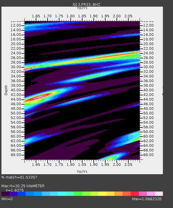
| Estimated Moho Depth: |
30.25 km |
| Estimated Crust Vp/Vs: |
1.63 |
| Assumed Crust Vp: |
6.601 km/s |
| Estimated Crust Vs: |
4.056 km/s |
| Estimated Crust Poisson's Ratio: |
0.20 |
|
| Radial Match: |
81.53357 % |
| Radial Bump: |
385 |
| Transverse Match: |
67.64199 % |
| Transverse Bump: |
400 |
| SOD ConfigId: |
3390531 |
| Insert Time: |
2019-04-13 10:56:38.918 +0000 |
| GWidth: |
2.5 |
| Max Bumps: |
400 |
| Tol: |
0.001 |
|

Signal To Noise
| Channel | StoN | STA | LTA |
| XJ:PR33: :BHZ:20140818T18:15:01.419985Z | 2.6579242 | 2.9331002E-7 | 1.10353035E-7 |
| XJ:PR33: :BHN:20140818T18:15:01.419985Z | 1.0370369 | 1.4897567E-7 | 1.4365514E-7 |
| XJ:PR33: :BHE:20140818T18:15:01.419985Z | 1.5801334 | 2.2624086E-7 | 1.4317833E-7 |
| Arrivals |
| Ps | 3.1 SECOND |
| PpPs | 11 SECOND |
| PsPs/PpSs | 14 SECOND |


