You are here: Home > Network List > TA - USArray Transportable Network (new EarthScope stations) Stations List
> Station F39A Loretta, WI, USA > Earthquake Result Viewer
F39A Loretta, WI, USA - Earthquake Result Viewer
| Earthquake location: |
Near Coast Of Nicaragua |
| Earthquake latitude/longitude: |
11.8/-86.9 |
| Earthquake time(UTC): |
2013/06/15 (166) 17:34:27 GMT |
| Earthquake Depth: |
30 km |
| Earthquake Magnitude: |
6.5 MW, 6.1 MB, 6.3 MS, 6.5 MW |
| Earthquake Catalog/Contributor: |
NEIC PDE/NEIC PDE-W |
|
| Network: |
TA USArray Transportable Network (new EarthScope stations) |
| Station: |
F39A Loretta, WI, USA |
| Lat/Lon: |
45.92 N/90.92 W |
| Elevation: |
440 m |
|
| Distance: |
34.2 deg |
| Az: |
355.039 deg |
| Baz: |
173.033 deg |
| Ray Param: |
0.07780835 |
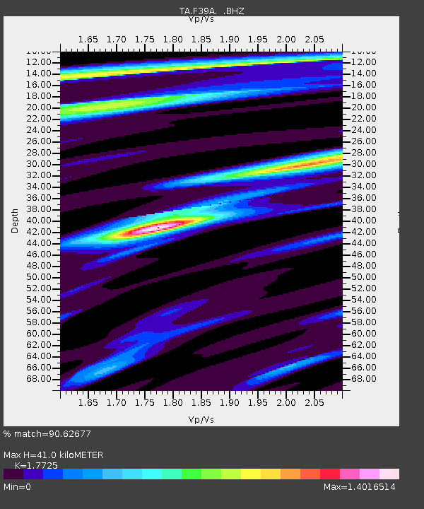
| Estimated Moho Depth: |
41.0 km |
| Estimated Crust Vp/Vs: |
1.77 |
| Assumed Crust Vp: |
6.571 km/s |
| Estimated Crust Vs: |
3.707 km/s |
| Estimated Crust Poisson's Ratio: |
0.27 |
|
| Radial Match: |
90.62677 % |
| Radial Bump: |
268 |
| Transverse Match: |
73.49474 % |
| Transverse Bump: |
400 |
| SOD ConfigId: |
512894 |
| Insert Time: |
2013-09-15 05:03:19.015 +0000 |
| GWidth: |
2.5 |
| Max Bumps: |
400 |
| Tol: |
0.001 |
|
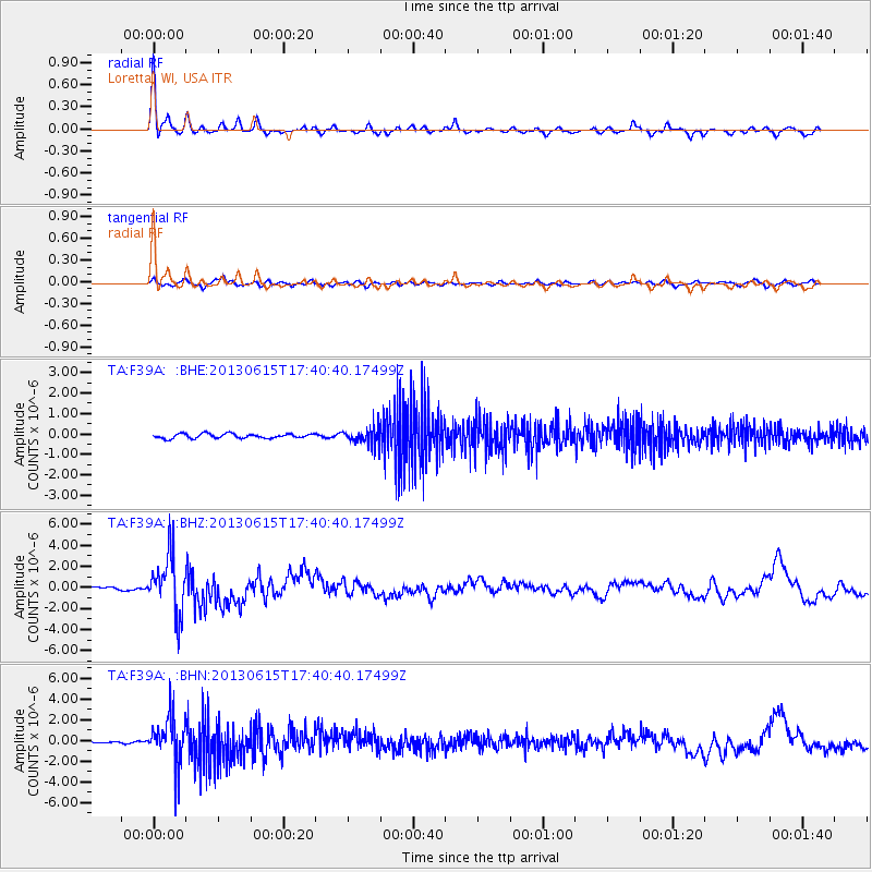
Signal To Noise
| Channel | StoN | STA | LTA |
| TA:F39A: :BHZ:20130615T17:40:40.17499Z | 17.49071 | 2.74304E-6 | 1.5682839E-7 |
| TA:F39A: :BHN:20130615T17:40:40.17499Z | 27.743265 | 2.2981283E-6 | 8.283554E-8 |
| TA:F39A: :BHE:20130615T17:40:40.17499Z | 3.7387702 | 4.107176E-7 | 1.0985366E-7 |
| Arrivals |
| Ps | 5.2 SECOND |
| PpPs | 16 SECOND |
| PsPs/PpSs | 21 SECOND |


