You are here: Home > Network List > XJ13 - CRAFTI Stations List
> Station PR31 Engaruka Boma > Earthquake Result Viewer
PR31 Engaruka Boma - Earthquake Result Viewer
| Earthquake location: |
Iran-Iraq Border Region |
| Earthquake latitude/longitude: |
32.6/47.7 |
| Earthquake time(UTC): |
2014/08/18 (230) 18:08:23 GMT |
| Earthquake Depth: |
10 km |
| Earthquake Magnitude: |
5.7 MWB |
| Earthquake Catalog/Contributor: |
NEIC PDE/NEIC COMCAT |
|
| Network: |
XJ CRAFTI |
| Station: |
PR31 Engaruka Boma |
| Lat/Lon: |
2.92 S/36.05 E |
| Elevation: |
884 m |
|
| Distance: |
37.0 deg |
| Az: |
199.595 deg |
| Baz: |
16.474 deg |
| Ray Param: |
0.07639178 |
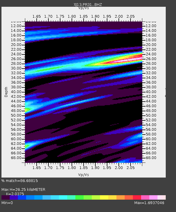
| Estimated Moho Depth: |
26.25 km |
| Estimated Crust Vp/Vs: |
2.04 |
| Assumed Crust Vp: |
6.601 km/s |
| Estimated Crust Vs: |
3.24 km/s |
| Estimated Crust Poisson's Ratio: |
0.34 |
|
| Radial Match: |
86.68815 % |
| Radial Bump: |
400 |
| Transverse Match: |
63.13065 % |
| Transverse Bump: |
400 |
| SOD ConfigId: |
3390531 |
| Insert Time: |
2019-04-13 10:56:39.645 +0000 |
| GWidth: |
2.5 |
| Max Bumps: |
400 |
| Tol: |
0.001 |
|

Signal To Noise
| Channel | StoN | STA | LTA |
| XJ:PR31: :BHZ:20140818T18:15:02.280001Z | 3.3759253 | 3.1372832E-7 | 9.293107E-8 |
| XJ:PR31: :BHN:20140818T18:15:02.280001Z | 1.4816866 | 1.4651117E-7 | 9.8881344E-8 |
| XJ:PR31: :BHE:20140818T18:15:02.280001Z | 1.4074425 | 1.732569E-7 | 1.2310052E-7 |
| Arrivals |
| Ps | 4.4 SECOND |
| PpPs | 11 SECOND |
| PsPs/PpSs | 16 SECOND |


