You are here: Home > Network List > XJ13 - CRAFTI Stations List
> Station PR62 Oldupai Boma > Earthquake Result Viewer
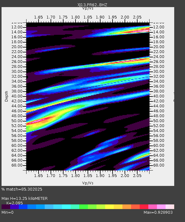
PR62 Oldupai Boma - Earthquake Result Viewer
| Earthquake location: |
Iran-Iraq Border Region |
| Earthquake latitude/longitude: |
32.6/47.7 |
| Earthquake time(UTC): |
2014/08/18 (230) 18:08:23 GMT |
| Earthquake Depth: |
10 km |
| Earthquake Magnitude: |
5.7 MWB |
| Earthquake Catalog/Contributor: |
NEIC PDE/NEIC COMCAT |
|
| Network: |
XJ CRAFTI |
| Station: |
PR62 Oldupai Boma |
| Lat/Lon: |
2.98 S/35.37 E |
| Elevation: |
1454 m |
|
| Distance: |
37.2 deg |
| Az: |
200.632 deg |
| Baz: |
17.336 deg |
| Ray Param: |
0.076251805 |
| Estimated Moho Depth: |
13.25 km |
| Estimated Crust Vp/Vs: |
2.10 |
| Assumed Crust Vp: |
6.576 km/s |
| Estimated Crust Vs: |
3.139 km/s |
| Estimated Crust Poisson's Ratio: |
0.35 |
|
| Radial Match: |
85.302025 % |
| Radial Bump: |
400 |
| Transverse Match: |
62.972977 % |
| Transverse Bump: |
400 |
| SOD ConfigId: |
3390531 |
| Insert Time: |
2019-04-13 10:56:40.077 +0000 |
| GWidth: |
2.5 |
| Max Bumps: |
400 |
| Tol: |
0.001 |
|

Signal To Noise
| Channel | StoN | STA | LTA |
| XJ:PR62: :BHZ:20140818T18:15:04.459994Z | 2.6415372 | 4.148365E-7 | 1.570436E-7 |
| XJ:PR62: :BHN:20140818T18:15:04.459994Z | 1.1863067 | 2.094269E-7 | 1.765369E-7 |
| XJ:PR62: :BHE:20140818T18:15:04.459994Z | 0.89159834 | 1.2152164E-7 | 1.3629639E-7 |
| Arrivals |
| Ps | 2.4 SECOND |
| PpPs | 5.8 SECOND |
| PsPs/PpSs | 8.2 SECOND |


