You are here: Home > Network List > TA - USArray Transportable Network (new EarthScope stations) Stations List
> Station J49A Marlette, MI, USA > Earthquake Result Viewer
J49A Marlette, MI, USA - Earthquake Result Viewer
| Earthquake location: |
Near Coast Of Nicaragua |
| Earthquake latitude/longitude: |
11.8/-86.9 |
| Earthquake time(UTC): |
2013/06/15 (166) 17:34:27 GMT |
| Earthquake Depth: |
30 km |
| Earthquake Magnitude: |
6.5 MW, 6.1 MB, 6.3 MS, 6.5 MW |
| Earthquake Catalog/Contributor: |
NEIC PDE/NEIC PDE-W |
|
| Network: |
TA USArray Transportable Network (new EarthScope stations) |
| Station: |
J49A Marlette, MI, USA |
| Lat/Lon: |
43.36 N/83.14 W |
| Elevation: |
253 m |
|
| Distance: |
31.7 deg |
| Az: |
5.267 deg |
| Baz: |
187.08 deg |
| Ray Param: |
0.07894302 |
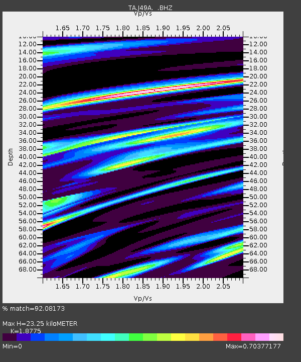
| Estimated Moho Depth: |
23.25 km |
| Estimated Crust Vp/Vs: |
1.88 |
| Assumed Crust Vp: |
6.483 km/s |
| Estimated Crust Vs: |
3.453 km/s |
| Estimated Crust Poisson's Ratio: |
0.30 |
|
| Radial Match: |
92.08173 % |
| Radial Bump: |
367 |
| Transverse Match: |
63.28272 % |
| Transverse Bump: |
400 |
| SOD ConfigId: |
512894 |
| Insert Time: |
2013-09-15 05:06:34.330 +0000 |
| GWidth: |
2.5 |
| Max Bumps: |
400 |
| Tol: |
0.001 |
|
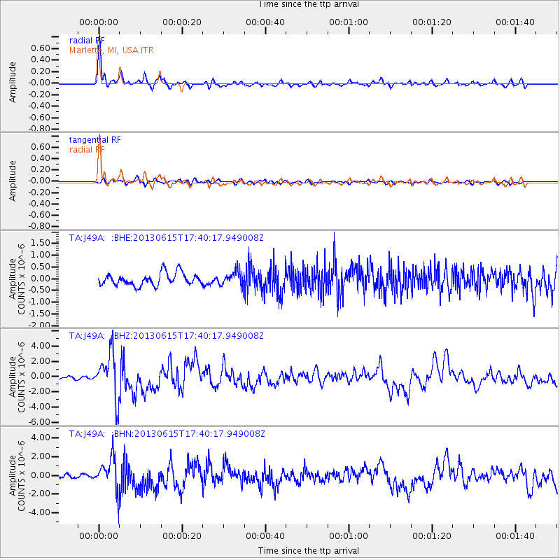
Signal To Noise
| Channel | StoN | STA | LTA |
| TA:J49A: :BHZ:20130615T17:40:17.949008Z | 13.228987 | 3.0092554E-6 | 2.2747436E-7 |
| TA:J49A: :BHN:20130615T17:40:17.949008Z | 10.787144 | 1.8135081E-6 | 1.6811755E-7 |
| TA:J49A: :BHE:20130615T17:40:17.949008Z | 1.1826311 | 3.1029933E-7 | 2.6238047E-7 |
| Arrivals |
| Ps | 3.4 SECOND |
| PpPs | 9.6 SECOND |
| PsPs/PpSs | 13 SECOND |


