You are here: Home > Network List > TA - USArray Transportable Network (new EarthScope stations) Stations List
> Station K43A Burlington, WI, USA > Earthquake Result Viewer
K43A Burlington, WI, USA - Earthquake Result Viewer
| Earthquake location: |
Near Coast Of Nicaragua |
| Earthquake latitude/longitude: |
11.8/-86.9 |
| Earthquake time(UTC): |
2013/06/15 (166) 17:34:27 GMT |
| Earthquake Depth: |
30 km |
| Earthquake Magnitude: |
6.5 MW, 6.1 MB, 6.3 MS, 6.5 MW |
| Earthquake Catalog/Contributor: |
NEIC PDE/NEIC PDE-W |
|
| Network: |
TA USArray Transportable Network (new EarthScope stations) |
| Station: |
K43A Burlington, WI, USA |
| Lat/Lon: |
42.70 N/88.33 W |
| Elevation: |
264 m |
|
| Distance: |
30.9 deg |
| Az: |
357.979 deg |
| Baz: |
177.314 deg |
| Ray Param: |
0.079197094 |
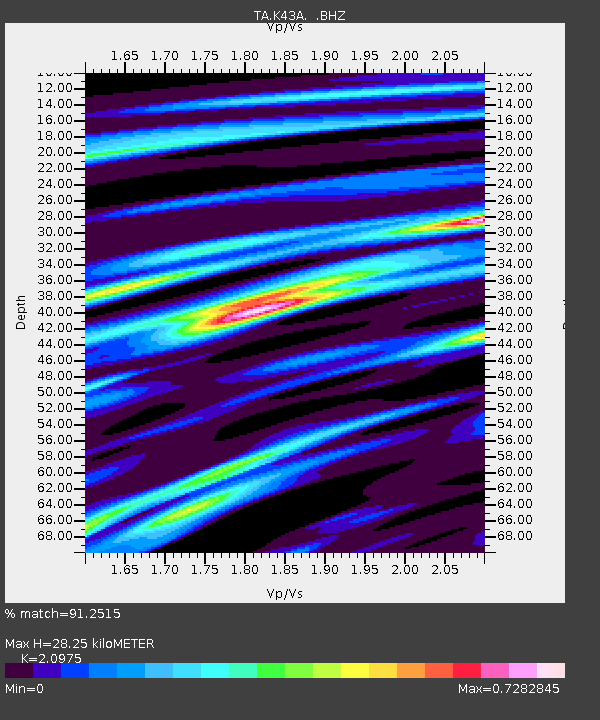
| Estimated Moho Depth: |
28.25 km |
| Estimated Crust Vp/Vs: |
2.10 |
| Assumed Crust Vp: |
6.571 km/s |
| Estimated Crust Vs: |
3.133 km/s |
| Estimated Crust Poisson's Ratio: |
0.35 |
|
| Radial Match: |
91.2515 % |
| Radial Bump: |
295 |
| Transverse Match: |
63.26221 % |
| Transverse Bump: |
400 |
| SOD ConfigId: |
512894 |
| Insert Time: |
2013-09-15 05:07:01.172 +0000 |
| GWidth: |
2.5 |
| Max Bumps: |
400 |
| Tol: |
0.001 |
|
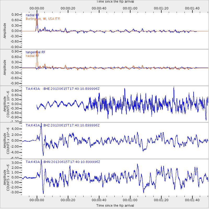
Signal To Noise
| Channel | StoN | STA | LTA |
| TA:K43A: :BHZ:20130615T17:40:10.899996Z | 24.289906 | 2.6204746E-6 | 1.07883274E-7 |
| TA:K43A: :BHN:20130615T17:40:10.899996Z | 12.367298 | 1.6530433E-6 | 1.3366244E-7 |
| TA:K43A: :BHE:20130615T17:40:10.899996Z | 1.888983 | 2.4960357E-7 | 1.3213649E-7 |
| Arrivals |
| Ps | 5.1 SECOND |
| PpPs | 12 SECOND |
| PsPs/PpSs | 17 SECOND |


