You are here: Home > Network List > TA - USArray Transportable Network (new EarthScope stations) Stations List
> Station L42A Oliver, Polo, IL, USA > Earthquake Result Viewer
L42A Oliver, Polo, IL, USA - Earthquake Result Viewer

| Earthquake location: |
Near Coast Of Nicaragua |
| Earthquake latitude/longitude: |
11.8/-86.9 |
| Earthquake time(UTC): |
2013/06/15 (166) 17:34:27 GMT |
| Earthquake Depth: |
30 km |
| Earthquake Magnitude: |
6.5 MW, 6.1 MB, 6.3 MS, 6.5 MW |
| Earthquake Catalog/Contributor: |
NEIC PDE/NEIC PDE-W |
|
| Network: |
TA USArray Transportable Network (new EarthScope stations) |
| Station: |
L42A Oliver, Polo, IL, USA |
| Lat/Lon: |
42.00 N/89.67 W |
| Elevation: |
257 m |
|
| Distance: |
30.2 deg |
| Az: |
355.939 deg |
| Baz: |
174.662 deg |
| Ray Param: |
0.07936228 |
| Estimated Moho Depth: |
49.75 km |
| Estimated Crust Vp/Vs: |
1.78 |
| Assumed Crust Vp: |
6.571 km/s |
| Estimated Crust Vs: |
3.697 km/s |
| Estimated Crust Poisson's Ratio: |
0.27 |
|
| Radial Match: |
93.0202 % |
| Radial Bump: |
315 |
| Transverse Match: |
69.95278 % |
| Transverse Bump: |
400 |
| SOD ConfigId: |
512894 |
| Insert Time: |
2013-09-15 05:07:58.471 +0000 |
| GWidth: |
2.5 |
| Max Bumps: |
400 |
| Tol: |
0.001 |
|
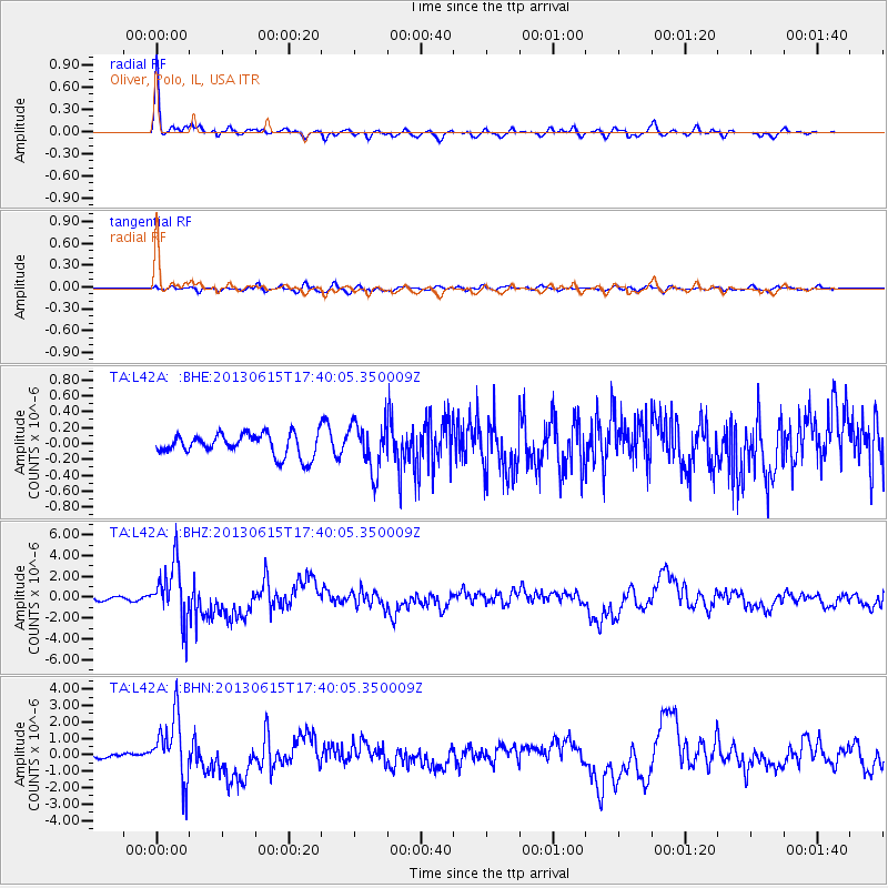
Signal To Noise
| Channel | StoN | STA | LTA |
| TA:L42A: :BHZ:20130615T17:40:05.350009Z | 16.415276 | 2.7963758E-6 | 1.7035204E-7 |
| TA:L42A: :BHN:20130615T17:40:05.350009Z | 18.055109 | 1.9095105E-6 | 1.05760115E-7 |
| TA:L42A: :BHE:20130615T17:40:05.350009Z | 2.1811757 | 2.9764252E-7 | 1.3645966E-7 |
| Arrivals |
| Ps | 6.4 SECOND |
| PpPs | 19 SECOND |
| PsPs/PpSs | 26 SECOND |


