You are here: Home > Network List > TA - USArray Transportable Network (new EarthScope stations) Stations List
> Station L54A Sinclairville, NY, USA > Earthquake Result Viewer
L54A Sinclairville, NY, USA - Earthquake Result Viewer
| Earthquake location: |
Near Coast Of Nicaragua |
| Earthquake latitude/longitude: |
11.8/-86.9 |
| Earthquake time(UTC): |
2013/06/15 (166) 17:34:27 GMT |
| Earthquake Depth: |
30 km |
| Earthquake Magnitude: |
6.5 MW, 6.1 MB, 6.3 MS, 6.5 MW |
| Earthquake Catalog/Contributor: |
NEIC PDE/NEIC PDE-W |
|
| Network: |
TA USArray Transportable Network (new EarthScope stations) |
| Station: |
L54A Sinclairville, NY, USA |
| Lat/Lon: |
42.23 N/79.32 W |
| Elevation: |
432 m |
|
| Distance: |
31.1 deg |
| Az: |
10.984 deg |
| Baz: |
194.551 deg |
| Ray Param: |
0.07913812 |
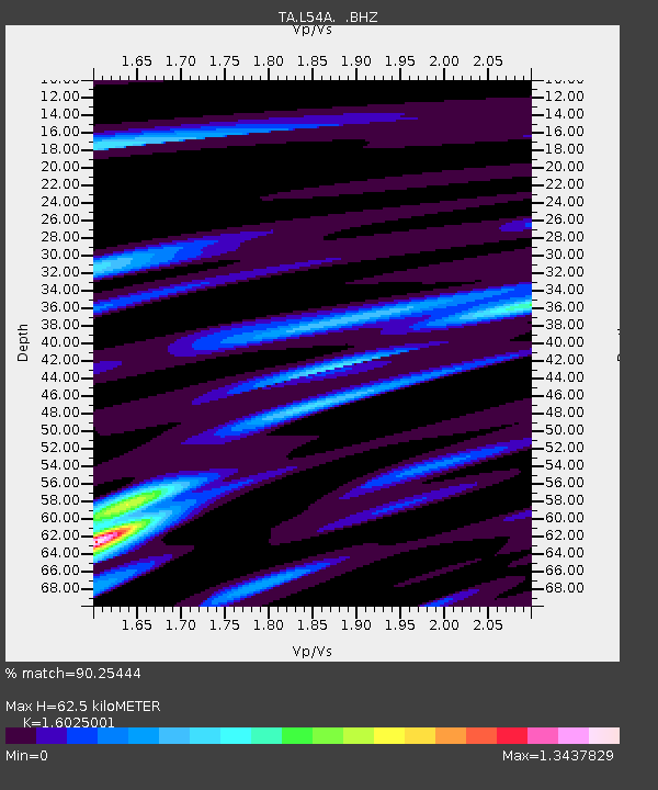
| Estimated Moho Depth: |
62.5 km |
| Estimated Crust Vp/Vs: |
1.60 |
| Assumed Crust Vp: |
6.419 km/s |
| Estimated Crust Vs: |
4.006 km/s |
| Estimated Crust Poisson's Ratio: |
0.18 |
|
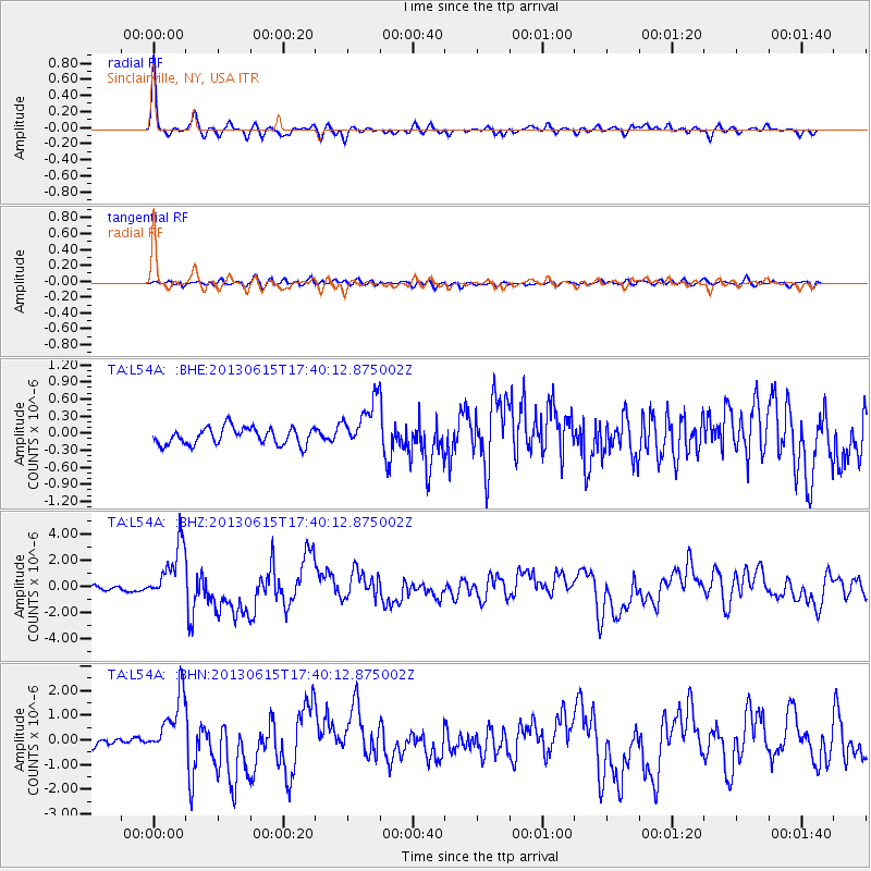
| Radial Match: |
90.25444 % |
| Radial Bump: |
316 |
| Transverse Match: |
59.836193 % |
| Transverse Bump: |
400 |
| SOD ConfigId: |
512894 |
| Insert Time: |
2013-09-15 05:08:22.414 +0000 |
| GWidth: |
2.5 |
| Max Bumps: |
400 |
| Tol: |
0.001 |
|
Signal To Noise
| Channel | StoN | STA | LTA |
| TA:L54A: :BHZ:20130615T17:40:12.875002Z | 14.778076 | 2.1495798E-6 | 1.4545735E-7 |
| TA:L54A: :BHN:20130615T17:40:12.875002Z | 8.613796 | 1.2294432E-6 | 1.4272955E-7 |
| TA:L54A: :BHE:20130615T17:40:12.875002Z | 2.897706 | 4.3222795E-7 | 1.491621E-7 |
| Arrivals |
| Ps | 6.4 SECOND |
| PpPs | 23 SECOND |
| PsPs/PpSs | 30 SECOND |


