You are here: Home > Network List > TA - USArray Transportable Network (new EarthScope stations) Stations List
> Station M56A Emporium, PA, USA > Earthquake Result Viewer
M56A Emporium, PA, USA - Earthquake Result Viewer
| Earthquake location: |
Near Coast Of Nicaragua |
| Earthquake latitude/longitude: |
11.8/-86.9 |
| Earthquake time(UTC): |
2013/06/15 (166) 17:34:27 GMT |
| Earthquake Depth: |
30 km |
| Earthquake Magnitude: |
6.5 MW, 6.1 MB, 6.3 MS, 6.5 MW |
| Earthquake Catalog/Contributor: |
NEIC PDE/NEIC PDE-W |
|
| Network: |
TA USArray Transportable Network (new EarthScope stations) |
| Station: |
M56A Emporium, PA, USA |
| Lat/Lon: |
41.48 N/78.18 W |
| Elevation: |
493 m |
|
| Distance: |
30.6 deg |
| Az: |
12.972 deg |
| Baz: |
197.012 deg |
| Ray Param: |
0.07926724 |
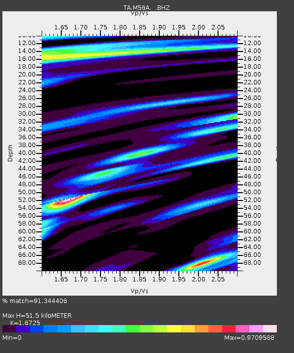
| Estimated Moho Depth: |
51.5 km |
| Estimated Crust Vp/Vs: |
1.67 |
| Assumed Crust Vp: |
6.121 km/s |
| Estimated Crust Vs: |
3.659 km/s |
| Estimated Crust Poisson's Ratio: |
0.22 |
|
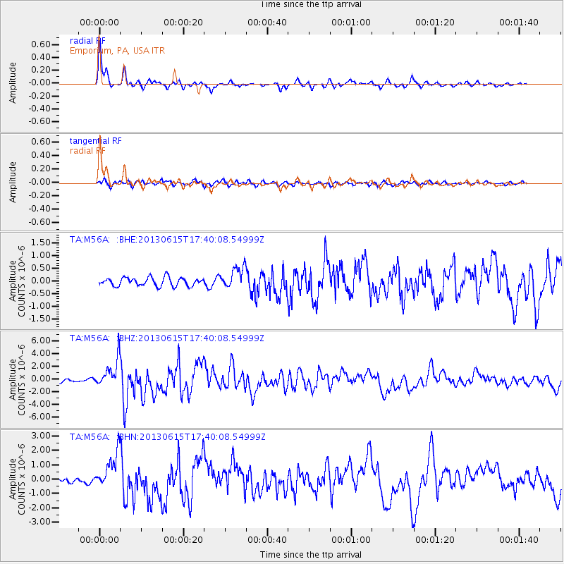
| Radial Match: |
91.344406 % |
| Radial Bump: |
293 |
| Transverse Match: |
72.01742 % |
| Transverse Bump: |
400 |
| SOD ConfigId: |
512894 |
| Insert Time: |
2013-09-15 05:08:49.745 +0000 |
| GWidth: |
2.5 |
| Max Bumps: |
400 |
| Tol: |
0.001 |
|
Signal To Noise
| Channel | StoN | STA | LTA |
| TA:M56A: :BHZ:20130615T17:40:08.54999Z | 9.557167 | 2.2931567E-6 | 2.3994107E-7 |
| TA:M56A: :BHN:20130615T17:40:08.54999Z | 5.6023517 | 1.2761988E-6 | 2.2779697E-7 |
| TA:M56A: :BHE:20130615T17:40:08.54999Z | 2.6076007 | 4.252595E-7 | 1.630846E-7 |
| Arrivals |
| Ps | 6.1 SECOND |
| PpPs | 21 SECOND |
| PsPs/PpSs | 27 SECOND |


