You are here: Home > Network List > UW - Pacific Northwest Regional Seismic Network Stations List
> Station BABR Baber Butte, OR, USA > Earthquake Result Viewer
BABR Baber Butte, OR, USA - Earthquake Result Viewer
| Earthquake location: |
Near Coast Of Nicaragua |
| Earthquake latitude/longitude: |
11.8/-86.9 |
| Earthquake time(UTC): |
2013/06/15 (166) 17:34:27 GMT |
| Earthquake Depth: |
30 km |
| Earthquake Magnitude: |
6.5 MW, 6.1 MB, 6.3 MS, 6.5 MW |
| Earthquake Catalog/Contributor: |
NEIC PDE/NEIC PDE-W |
|
| Network: |
UW Pacific Northwest Regional Seismic Network |
| Station: |
BABR Baber Butte, OR, USA |
| Lat/Lon: |
44.62 N/123.79 W |
| Elevation: |
418 m |
|
| Distance: |
45.5 deg |
| Az: |
323.061 deg |
| Baz: |
124.503 deg |
| Ray Param: |
0.07119936 |
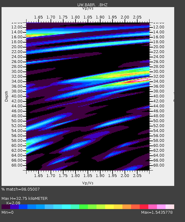
| Estimated Moho Depth: |
32.75 km |
| Estimated Crust Vp/Vs: |
2.09 |
| Assumed Crust Vp: |
6.566 km/s |
| Estimated Crust Vs: |
3.142 km/s |
| Estimated Crust Poisson's Ratio: |
0.35 |
|
| Radial Match: |
86.05007 % |
| Radial Bump: |
400 |
| Transverse Match: |
65.34922 % |
| Transverse Bump: |
400 |
| SOD ConfigId: |
512894 |
| Insert Time: |
2013-09-15 05:13:41.021 +0000 |
| GWidth: |
2.5 |
| Max Bumps: |
400 |
| Tol: |
0.001 |
|

Signal To Noise
| Channel | StoN | STA | LTA |
| UW:BABR: :BHZ:20130615T17:42:13.524996Z | 7.8252 | 1.7106364E-6 | 2.1860609E-7 |
| UW:BABR: :BHN:20130615T17:42:13.524996Z | 1.7006042 | 4.7494146E-7 | 2.7927805E-7 |
| UW:BABR: :BHE:20130615T17:42:13.524996Z | 2.9539232 | 7.7447646E-7 | 2.6218572E-7 |
| Arrivals |
| Ps | 5.8 SECOND |
| PpPs | 15 SECOND |
| PsPs/PpSs | 20 SECOND |


