You are here: Home > Network List > CN - Canadian National Seismograph Network Stations List
> Station GAC GLEN ALMOND, QC > Earthquake Result Viewer
GAC GLEN ALMOND, QC - Earthquake Result Viewer
| Earthquake location: |
Guerrero, Mexico |
| Earthquake latitude/longitude: |
18.2/-99.2 |
| Earthquake time(UTC): |
2013/06/16 (167) 05:19:00 GMT |
| Earthquake Depth: |
52 km |
| Earthquake Magnitude: |
5.8 MW, 5.8 MW, 5.9 MB |
| Earthquake Catalog/Contributor: |
NEIC PDE/NEIC PDE-W |
|
| Network: |
CN Canadian National Seismograph Network |
| Station: |
GAC GLEN ALMOND, QC |
| Lat/Lon: |
45.70 N/75.48 W |
| Elevation: |
62 m |
|
| Distance: |
33.8 deg |
| Az: |
30.45 deg |
| Baz: |
223.442 deg |
| Ray Param: |
0.0779234 |
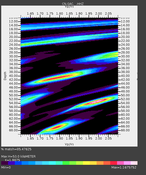
| Estimated Moho Depth: |
53.0 km |
| Estimated Crust Vp/Vs: |
1.99 |
| Assumed Crust Vp: |
6.419 km/s |
| Estimated Crust Vs: |
3.23 km/s |
| Estimated Crust Poisson's Ratio: |
0.33 |
|
| Radial Match: |
85.47625 % |
| Radial Bump: |
400 |
| Transverse Match: |
62.8664 % |
| Transverse Bump: |
400 |
| SOD ConfigId: |
512894 |
| Insert Time: |
2013-09-15 05:29:50.169 +0000 |
| GWidth: |
2.5 |
| Max Bumps: |
400 |
| Tol: |
0.001 |
|

Signal To Noise
| Channel | StoN | STA | LTA |
| CN:GAC: :HHZ:20130616T05:25:06.790009Z | 2.722615 | 1.4561174E-7 | 5.348231E-8 |
| CN:GAC: :HHN:20130616T05:25:06.790009Z | 1.505624 | 6.143528E-8 | 4.0803865E-8 |
| CN:GAC: :HHE:20130616T05:25:06.790009Z | 1.6560123 | 6.462563E-8 | 3.9024847E-8 |
| Arrivals |
| Ps | 8.7 SECOND |
| PpPs | 23 SECOND |
| PsPs/PpSs | 32 SECOND |


