You are here: Home > Network List > TA - USArray Transportable Network (new EarthScope stations) Stations List
> Station M61A Granite Springs, NY, USA > Earthquake Result Viewer
M61A Granite Springs, NY, USA - Earthquake Result Viewer
| Earthquake location: |
Iran-Iraq Border Region |
| Earthquake latitude/longitude: |
32.5/47.7 |
| Earthquake time(UTC): |
2014/08/18 (230) 18:54:56 GMT |
| Earthquake Depth: |
20 km |
| Earthquake Magnitude: |
4.9 MW, 4.7 mb |
| Earthquake Catalog/Contributor: |
ISC/ISC |
|
| Network: |
TA USArray Transportable Network (new EarthScope stations) |
| Station: |
M61A Granite Springs, NY, USA |
| Lat/Lon: |
41.31 N/73.77 W |
| Elevation: |
190 m |
|
| Distance: |
88.9 deg |
| Az: |
319.991 deg |
| Baz: |
46.17 deg |
| Ray Param: |
0.042228382 |
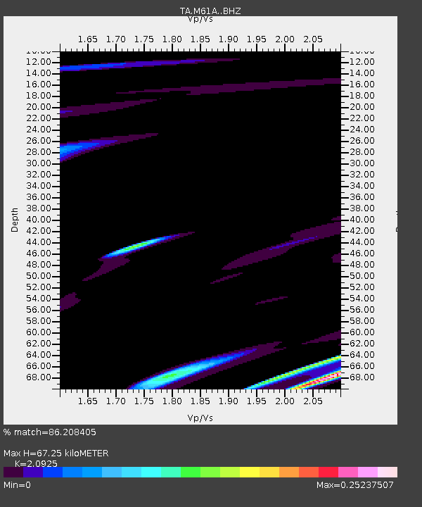
| Estimated Moho Depth: |
67.25 km |
| Estimated Crust Vp/Vs: |
2.09 |
| Assumed Crust Vp: |
6.472 km/s |
| Estimated Crust Vs: |
3.093 km/s |
| Estimated Crust Poisson's Ratio: |
0.35 |
|
| Radial Match: |
86.208405 % |
| Radial Bump: |
400 |
| Transverse Match: |
47.862316 % |
| Transverse Bump: |
400 |
| SOD ConfigId: |
3390531 |
| Insert Time: |
2019-04-13 11:07:05.004 +0000 |
| GWidth: |
2.5 |
| Max Bumps: |
400 |
| Tol: |
0.001 |
|

Signal To Noise
| Channel | StoN | STA | LTA |
| TA:M61A: :BHZ:20140818T19:07:17.549976Z | 0.70931596 | 2.0054783E-7 | 2.8273413E-7 |
| TA:M61A: :BHN:20140818T19:07:17.549976Z | 1.4257418 | 3.3047138E-7 | 2.3178909E-7 |
| TA:M61A: :BHE:20140818T19:07:17.549976Z | 1.6095926 | 2.9976988E-7 | 1.862396E-7 |
| Arrivals |
| Ps | 12 SECOND |
| PpPs | 32 SECOND |
| PsPs/PpSs | 43 SECOND |


