You are here: Home > Network List > G - GEOSCOPE Stations List
> Station TAM Tamanrasset, Algeria > Earthquake Result Viewer
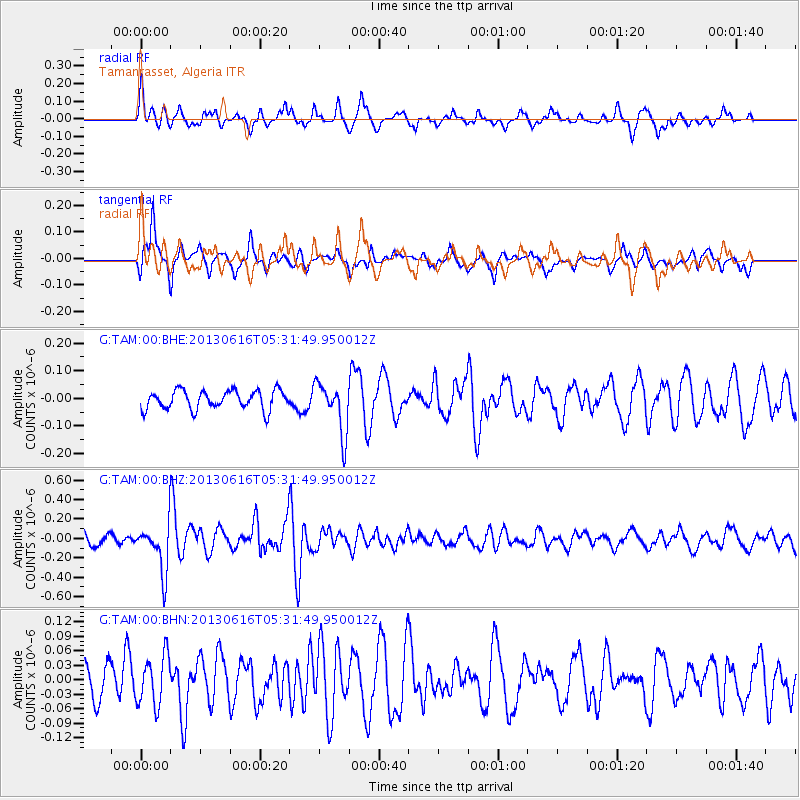
TAM Tamanrasset, Algeria - Earthquake Result Viewer
*The percent match for this event was below the threshold and hence no stack was calculated.
| Earthquake location: |
Guerrero, Mexico |
| Earthquake latitude/longitude: |
18.2/-99.2 |
| Earthquake time(UTC): |
2013/06/16 (167) 05:19:00 GMT |
| Earthquake Depth: |
52 km |
| Earthquake Magnitude: |
5.8 MW, 5.8 MW, 5.9 MB |
| Earthquake Catalog/Contributor: |
NEIC PDE/NEIC PDE-W |
|
| Network: |
G GEOSCOPE |
| Station: |
TAM Tamanrasset, Algeria |
| Lat/Lon: |
22.79 N/5.53 E |
| Elevation: |
1377 m |
|
| Distance: |
96.0 deg |
| Az: |
63.814 deg |
| Baz: |
292.395 deg |
| Ray Param: |
$rayparam |
*The percent match for this event was below the threshold and hence was not used in the summary stack. |
|
| Radial Match: |
53.57327 % |
| Radial Bump: |
400 |
| Transverse Match: |
75.966034 % |
| Transverse Bump: |
400 |
| SOD ConfigId: |
512894 |
| Insert Time: |
2013-09-15 05:32:15.517 +0000 |
| GWidth: |
2.5 |
| Max Bumps: |
400 |
| Tol: |
0.001 |
|
Signal To Noise
| Channel | StoN | STA | LTA |
| G:TAM:00:BHZ:20130616T05:31:49.950012Z | 3.9160843 | 2.449099E-7 | 6.2539485E-8 |
| G:TAM:00:BHN:20130616T05:31:49.950012Z | 1.2663342 | 5.1145637E-8 | 4.0388734E-8 |
| G:TAM:00:BHE:20130616T05:31:49.950012Z | 2.7240956 | 9.306908E-8 | 3.416513E-8 |
| Arrivals |
| Ps | |
| PpPs | |
| PsPs/PpSs | |


