You are here: Home > Network List > US - United States National Seismic Network Stations List
> Station ERPA Erie, Pennsylvania, USA > Earthquake Result Viewer
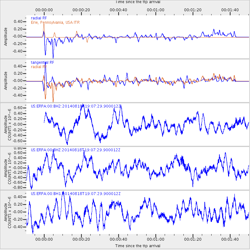
ERPA Erie, Pennsylvania, USA - Earthquake Result Viewer
*The percent match for this event was below the threshold and hence no stack was calculated.
| Earthquake location: |
Iran-Iraq Border Region |
| Earthquake latitude/longitude: |
32.5/47.7 |
| Earthquake time(UTC): |
2014/08/18 (230) 18:54:56 GMT |
| Earthquake Depth: |
20 km |
| Earthquake Magnitude: |
4.9 MW, 4.7 mb |
| Earthquake Catalog/Contributor: |
ISC/ISC |
|
| Network: |
US United States National Seismic Network |
| Station: |
ERPA Erie, Pennsylvania, USA |
| Lat/Lon: |
42.12 N/79.99 W |
| Elevation: |
306 m |
|
| Distance: |
91.6 deg |
| Az: |
323.896 deg |
| Baz: |
42.027 deg |
| Ray Param: |
$rayparam |
*The percent match for this event was below the threshold and hence was not used in the summary stack. |
|
| Radial Match: |
79.53087 % |
| Radial Bump: |
400 |
| Transverse Match: |
69.621864 % |
| Transverse Bump: |
400 |
| SOD ConfigId: |
3390531 |
| Insert Time: |
2019-04-13 11:07:38.877 +0000 |
| GWidth: |
2.5 |
| Max Bumps: |
400 |
| Tol: |
0.001 |
|
Signal To Noise
| Channel | StoN | STA | LTA |
| US:ERPA:00:BHZ:20140818T19:07:29.900012Z | 0.7724039 | 3.5490663E-7 | 4.594832E-7 |
| US:ERPA:00:BH1:20140818T19:07:29.900012Z | 0.6979312 | 2.1667488E-7 | 3.1045306E-7 |
| US:ERPA:00:BH2:20140818T19:07:29.900012Z | 1.4606817 | 4.84567E-7 | 3.3174032E-7 |
| Arrivals |
| Ps | |
| PpPs | |
| PsPs/PpSs | |


