You are here: Home > Network List > LD - Lamont-Doherty Cooperative Seismographic Network Stations List
> Station FLET Fletcher, VT > Earthquake Result Viewer
FLET Fletcher, VT - Earthquake Result Viewer
| Earthquake location: |
Guerrero, Mexico |
| Earthquake latitude/longitude: |
18.2/-99.2 |
| Earthquake time(UTC): |
2013/06/16 (167) 05:19:00 GMT |
| Earthquake Depth: |
52 km |
| Earthquake Magnitude: |
5.8 MW, 5.8 MW, 5.9 MB |
| Earthquake Catalog/Contributor: |
NEIC PDE/NEIC PDE-W |
|
| Network: |
LD Lamont-Doherty Cooperative Seismographic Network |
| Station: |
FLET Fletcher, VT |
| Lat/Lon: |
44.72 N/72.95 W |
| Elevation: |
366 m |
|
| Distance: |
34.4 deg |
| Az: |
33.925 deg |
| Baz: |
228.107 deg |
| Ray Param: |
0.07763213 |
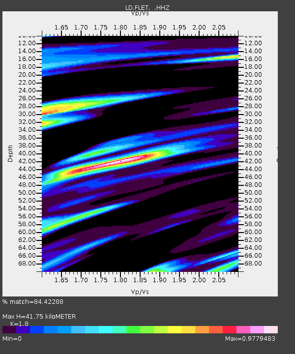
| Estimated Moho Depth: |
41.75 km |
| Estimated Crust Vp/Vs: |
1.80 |
| Assumed Crust Vp: |
6.419 km/s |
| Estimated Crust Vs: |
3.566 km/s |
| Estimated Crust Poisson's Ratio: |
0.28 |
|
| Radial Match: |
84.42288 % |
| Radial Bump: |
400 |
| Transverse Match: |
47.32075 % |
| Transverse Bump: |
400 |
| SOD ConfigId: |
512894 |
| Insert Time: |
2013-09-15 05:35:24.267 +0000 |
| GWidth: |
2.5 |
| Max Bumps: |
400 |
| Tol: |
0.001 |
|

Signal To Noise
| Channel | StoN | STA | LTA |
| LD:FLET: :HHZ:20130616T05:25:11.929993Z | 0.7066438 | 2.5885086E-10 | 3.663102E-10 |
| LD:FLET: :HHN:20130616T05:25:11.929993Z | 0.58892524 | 1.8864232E-10 | 3.2031627E-10 |
| LD:FLET: :HHE:20130616T05:25:11.929993Z | 0.553459 | 2.957399E-10 | 5.3434834E-10 |
| Arrivals |
| Ps | 5.6 SECOND |
| PpPs | 17 SECOND |
| PsPs/PpSs | 22 SECOND |


