You are here: Home > Network List > NE - New England Seismic Network Stations List
> Station BRYW Smithfield, RI, USA > Earthquake Result Viewer
BRYW Smithfield, RI, USA - Earthquake Result Viewer
| Earthquake location: |
Guerrero, Mexico |
| Earthquake latitude/longitude: |
18.2/-99.2 |
| Earthquake time(UTC): |
2013/06/16 (167) 05:19:00 GMT |
| Earthquake Depth: |
52 km |
| Earthquake Magnitude: |
5.8 MW, 5.8 MW, 5.9 MB |
| Earthquake Catalog/Contributor: |
NEIC PDE/NEIC PDE-W |
|
| Network: |
NE New England Seismic Network |
| Station: |
BRYW Smithfield, RI, USA |
| Lat/Lon: |
41.92 N/71.54 W |
| Elevation: |
116 m |
|
| Distance: |
33.4 deg |
| Az: |
38.987 deg |
| Baz: |
233.276 deg |
| Ray Param: |
0.078099236 |
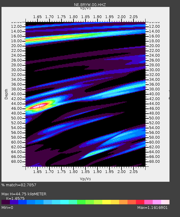
| Estimated Moho Depth: |
44.75 km |
| Estimated Crust Vp/Vs: |
1.66 |
| Assumed Crust Vp: |
6.472 km/s |
| Estimated Crust Vs: |
3.905 km/s |
| Estimated Crust Poisson's Ratio: |
0.21 |
|
| Radial Match: |
82.7857 % |
| Radial Bump: |
400 |
| Transverse Match: |
65.70075 % |
| Transverse Bump: |
400 |
| SOD ConfigId: |
512894 |
| Insert Time: |
2013-09-15 05:36:54.154 +0000 |
| GWidth: |
2.5 |
| Max Bumps: |
400 |
| Tol: |
0.001 |
|

Signal To Noise
| Channel | StoN | STA | LTA |
| NE:BRYW:00:HHZ:20130616T05:25:03.473999Z | 2.3709838 | 5.098886E-7 | 2.1505357E-7 |
| NE:BRYW:00:HH1:20130616T05:25:03.473999Z | 1.8921818 | 3.458597E-7 | 1.8278354E-7 |
| NE:BRYW:00:HH2:20130616T05:25:03.473999Z | 1.398176 | 2.589155E-7 | 1.8518091E-7 |
| Arrivals |
| Ps | 4.9 SECOND |
| PpPs | 17 SECOND |
| PsPs/PpSs | 22 SECOND |


