You are here: Home > Network List > NE - New England Seismic Network Stations List
> Station WSPT Westport, CT, USA > Earthquake Result Viewer
WSPT Westport, CT, USA - Earthquake Result Viewer
| Earthquake location: |
Guerrero, Mexico |
| Earthquake latitude/longitude: |
18.2/-99.2 |
| Earthquake time(UTC): |
2013/06/16 (167) 05:19:00 GMT |
| Earthquake Depth: |
52 km |
| Earthquake Magnitude: |
5.8 MW, 5.8 MW, 5.9 MB |
| Earthquake Catalog/Contributor: |
NEIC PDE/NEIC PDE-W |
|
| Network: |
NE New England Seismic Network |
| Station: |
WSPT Westport, CT, USA |
| Lat/Lon: |
41.17 N/73.33 W |
| Elevation: |
91 m |
|
| Distance: |
31.9 deg |
| Az: |
38.567 deg |
| Baz: |
231.74 deg |
| Ray Param: |
0.078771286 |
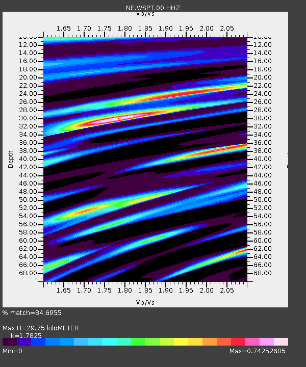
| Estimated Moho Depth: |
29.75 km |
| Estimated Crust Vp/Vs: |
1.78 |
| Assumed Crust Vp: |
6.472 km/s |
| Estimated Crust Vs: |
3.631 km/s |
| Estimated Crust Poisson's Ratio: |
0.27 |
|
| Radial Match: |
84.6955 % |
| Radial Bump: |
317 |
| Transverse Match: |
65.2153 % |
| Transverse Bump: |
400 |
| SOD ConfigId: |
512894 |
| Insert Time: |
2013-09-15 05:37:22.167 +0000 |
| GWidth: |
2.5 |
| Max Bumps: |
400 |
| Tol: |
0.001 |
|

Signal To Noise
| Channel | StoN | STA | LTA |
| NE:WSPT:00:HHZ:20130616T05:24:50.223999Z | 4.2507224 | 7.618137E-7 | 1.7921982E-7 |
| NE:WSPT:00:HH1:20130616T05:24:50.223999Z | 1.8031842 | 2.0335443E-7 | 1.1277519E-7 |
| NE:WSPT:00:HH2:20130616T05:24:50.223999Z | 4.1206155 | 5.2545323E-7 | 1.2751813E-7 |
| Arrivals |
| Ps | 3.9 SECOND |
| PpPs | 12 SECOND |
| PsPs/PpSs | 16 SECOND |


