You are here: Home > Network List > TA - USArray Transportable Network (new EarthScope stations) Stations List
> Station E44A Grand Marais Airport, Grand Marais, MI, USA > Earthquake Result Viewer
E44A Grand Marais Airport, Grand Marais, MI, USA - Earthquake Result Viewer
| Earthquake location: |
Guerrero, Mexico |
| Earthquake latitude/longitude: |
18.2/-99.2 |
| Earthquake time(UTC): |
2013/06/16 (167) 05:19:00 GMT |
| Earthquake Depth: |
52 km |
| Earthquake Magnitude: |
5.8 MW, 5.8 MW, 5.9 MB |
| Earthquake Catalog/Contributor: |
NEIC PDE/NEIC PDE-W |
|
| Network: |
TA USArray Transportable Network (new EarthScope stations) |
| Station: |
E44A Grand Marais Airport, Grand Marais, MI, USA |
| Lat/Lon: |
46.62 N/85.92 W |
| Elevation: |
282 m |
|
| Distance: |
30.4 deg |
| Az: |
18.218 deg |
| Baz: |
205.548 deg |
| Ray Param: |
0.07926601 |
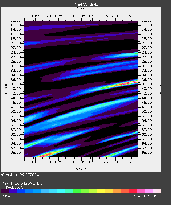
| Estimated Moho Depth: |
36.5 km |
| Estimated Crust Vp/Vs: |
2.10 |
| Assumed Crust Vp: |
6.467 km/s |
| Estimated Crust Vs: |
3.083 km/s |
| Estimated Crust Poisson's Ratio: |
0.35 |
|
| Radial Match: |
90.372986 % |
| Radial Bump: |
320 |
| Transverse Match: |
67.88931 % |
| Transverse Bump: |
400 |
| SOD ConfigId: |
512894 |
| Insert Time: |
2013-09-15 05:41:57.409 +0000 |
| GWidth: |
2.5 |
| Max Bumps: |
400 |
| Tol: |
0.001 |
|
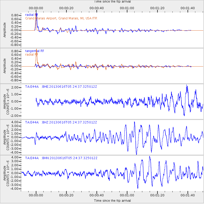
Signal To Noise
| Channel | StoN | STA | LTA |
| TA:E44A: :BHZ:20130616T05:24:37.325012Z | 3.6651 | 6.64392E-7 | 1.8127528E-7 |
| TA:E44A: :BHN:20130616T05:24:37.325012Z | 1.306034 | 3.8378946E-7 | 2.938587E-7 |
| TA:E44A: :BHE:20130616T05:24:37.325012Z | 1.3701767 | 2.9815342E-7 | 2.1760218E-7 |
| Arrivals |
| Ps | 6.6 SECOND |
| PpPs | 16 SECOND |
| PsPs/PpSs | 23 SECOND |


