You are here: Home > Network List > TA - USArray Transportable Network (new EarthScope stations) Stations List
> Station E50A Wahnapitae, ON, CAN > Earthquake Result Viewer
E50A Wahnapitae, ON, CAN - Earthquake Result Viewer
| Earthquake location: |
Guerrero, Mexico |
| Earthquake latitude/longitude: |
18.2/-99.2 |
| Earthquake time(UTC): |
2013/06/16 (167) 05:19:00 GMT |
| Earthquake Depth: |
52 km |
| Earthquake Magnitude: |
5.8 MW, 5.8 MW, 5.9 MB |
| Earthquake Catalog/Contributor: |
NEIC PDE/NEIC PDE-W |
|
| Network: |
TA USArray Transportable Network (new EarthScope stations) |
| Station: |
E50A Wahnapitae, ON, CAN |
| Lat/Lon: |
46.42 N/80.74 W |
| Elevation: |
242 m |
|
| Distance: |
32.1 deg |
| Az: |
24.381 deg |
| Baz: |
214.57 deg |
| Ray Param: |
0.07870565 |
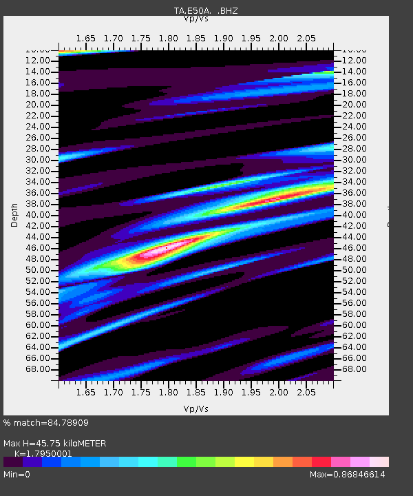
| Estimated Moho Depth: |
45.75 km |
| Estimated Crust Vp/Vs: |
1.80 |
| Assumed Crust Vp: |
6.467 km/s |
| Estimated Crust Vs: |
3.603 km/s |
| Estimated Crust Poisson's Ratio: |
0.27 |
|
| Radial Match: |
84.78909 % |
| Radial Bump: |
369 |
| Transverse Match: |
52.736347 % |
| Transverse Bump: |
400 |
| SOD ConfigId: |
512894 |
| Insert Time: |
2013-09-15 05:42:07.805 +0000 |
| GWidth: |
2.5 |
| Max Bumps: |
400 |
| Tol: |
0.001 |
|

Signal To Noise
| Channel | StoN | STA | LTA |
| TA:E50A: :BHZ:20130616T05:24:51.575012Z | 4.6168385 | 7.1491297E-7 | 1.5484902E-7 |
| TA:E50A: :BHN:20130616T05:24:51.575012Z | 3.0327184 | 5.2030657E-7 | 1.7156444E-7 |
| TA:E50A: :BHE:20130616T05:24:51.575012Z | 1.6227444 | 1.8748727E-7 | 1.15537155E-7 |
| Arrivals |
| Ps | 6.1 SECOND |
| PpPs | 18 SECOND |
| PsPs/PpSs | 24 SECOND |


