You are here: Home > Network List > TA - USArray Transportable Network (new EarthScope stations) Stations List
> Station E51A G1948 Merrick Township, ON, CAN > Earthquake Result Viewer
E51A G1948 Merrick Township, ON, CAN - Earthquake Result Viewer
| Earthquake location: |
Guerrero, Mexico |
| Earthquake latitude/longitude: |
18.2/-99.2 |
| Earthquake time(UTC): |
2013/06/16 (167) 05:19:00 GMT |
| Earthquake Depth: |
52 km |
| Earthquake Magnitude: |
5.8 MW, 5.8 MW, 5.9 MB |
| Earthquake Catalog/Contributor: |
NEIC PDE/NEIC PDE-W |
|
| Network: |
TA USArray Transportable Network (new EarthScope stations) |
| Station: |
E51A G1948 Merrick Township, ON, CAN |
| Lat/Lon: |
46.53 N/79.49 W |
| Elevation: |
369 m |
|
| Distance: |
32.6 deg |
| Az: |
25.571 deg |
| Baz: |
216.475 deg |
| Ray Param: |
0.07845539 |
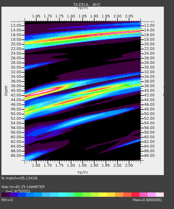
| Estimated Moho Depth: |
40.25 km |
| Estimated Crust Vp/Vs: |
1.68 |
| Assumed Crust Vp: |
6.622 km/s |
| Estimated Crust Vs: |
3.954 km/s |
| Estimated Crust Poisson's Ratio: |
0.22 |
|
| Radial Match: |
85.10426 % |
| Radial Bump: |
294 |
| Transverse Match: |
63.26827 % |
| Transverse Bump: |
357 |
| SOD ConfigId: |
512894 |
| Insert Time: |
2013-09-15 05:42:09.474 +0000 |
| GWidth: |
2.5 |
| Max Bumps: |
400 |
| Tol: |
0.001 |
|
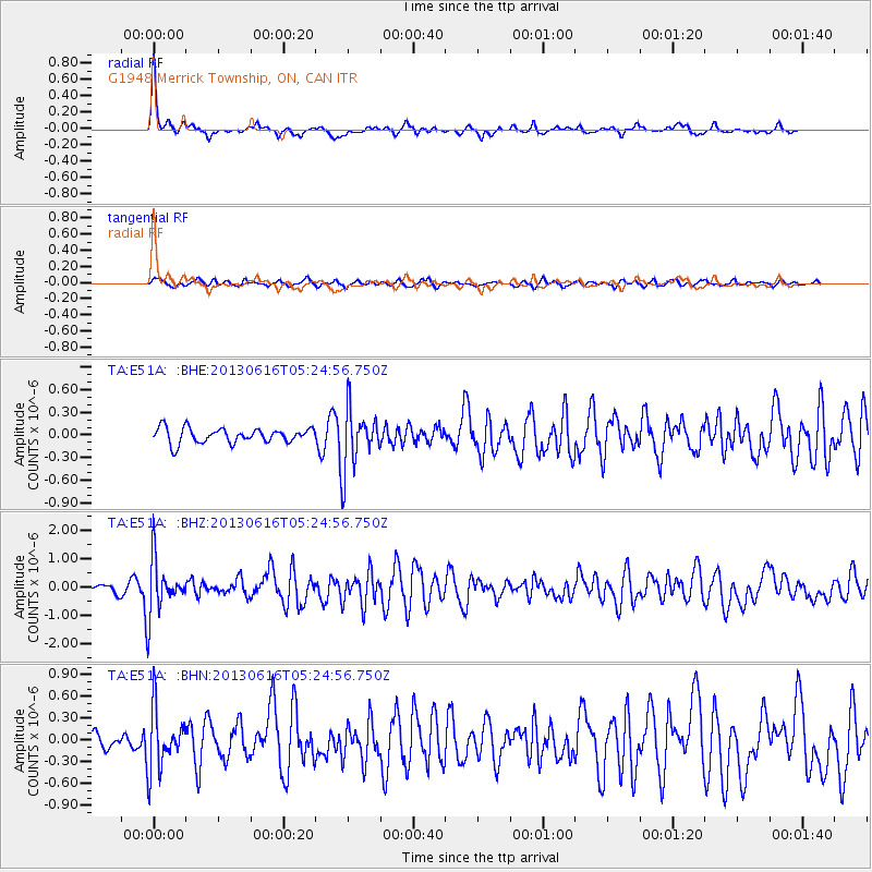
Signal To Noise
| Channel | StoN | STA | LTA |
| TA:E51A: :BHZ:20130616T05:24:56.750Z | 10.647858 | 9.5127507E-7 | 8.933957E-8 |
| TA:E51A: :BHN:20130616T05:24:56.750Z | 3.3624783 | 4.0912792E-7 | 1.2167452E-7 |
| TA:E51A: :BHE:20130616T05:24:56.750Z | 3.9508927 | 3.8997507E-7 | 9.8705556E-8 |
| Arrivals |
| Ps | 4.5 SECOND |
| PpPs | 15 SECOND |
| PsPs/PpSs | 19 SECOND |


