You are here: Home > Network List > TA - USArray Transportable Network (new EarthScope stations) Stations List
> Station H04D Lebanon, OR, USA > Earthquake Result Viewer
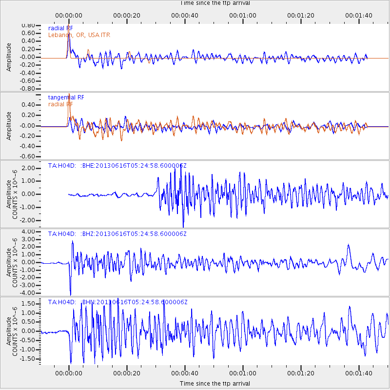
H04D Lebanon, OR, USA - Earthquake Result Viewer
*The percent match for this event was below the threshold and hence no stack was calculated.
| Earthquake location: |
Guerrero, Mexico |
| Earthquake latitude/longitude: |
18.2/-99.2 |
| Earthquake time(UTC): |
2013/06/16 (167) 05:19:00 GMT |
| Earthquake Depth: |
52 km |
| Earthquake Magnitude: |
5.8 MW, 5.8 MW, 5.9 MB |
| Earthquake Catalog/Contributor: |
NEIC PDE/NEIC PDE-W |
|
| Network: |
TA USArray Transportable Network (new EarthScope stations) |
| Station: |
H04D Lebanon, OR, USA |
| Lat/Lon: |
44.52 N/122.74 W |
| Elevation: |
284 m |
|
| Distance: |
32.9 deg |
| Az: |
328.237 deg |
| Baz: |
135.595 deg |
| Ray Param: |
$rayparam |
*The percent match for this event was below the threshold and hence was not used in the summary stack. |
|
| Radial Match: |
76.81409 % |
| Radial Bump: |
400 |
| Transverse Match: |
61.59593 % |
| Transverse Bump: |
400 |
| SOD ConfigId: |
512894 |
| Insert Time: |
2013-09-15 05:43:04.708 +0000 |
| GWidth: |
2.5 |
| Max Bumps: |
400 |
| Tol: |
0.001 |
|
Signal To Noise
| Channel | StoN | STA | LTA |
| TA:H04D: :BHZ:20130616T05:24:58.600006Z | 19.611162 | 1.4221945E-6 | 7.251965E-8 |
| TA:H04D: :BHN:20130616T05:24:58.600006Z | 9.406526 | 7.3441464E-7 | 7.807502E-8 |
| TA:H04D: :BHE:20130616T05:24:58.600006Z | 8.552166 | 6.805198E-7 | 7.95728E-8 |
| Arrivals |
| Ps | |
| PpPs | |
| PsPs/PpSs | |


