You are here: Home > Network List > UW - Pacific Northwest Regional Seismic Network Stations List
> Station BLOW Detroit Lake, OR, USA > Earthquake Result Viewer
BLOW Detroit Lake, OR, USA - Earthquake Result Viewer

| Earthquake location: |
Guerrero, Mexico |
| Earthquake latitude/longitude: |
18.2/-99.2 |
| Earthquake time(UTC): |
2013/06/16 (167) 05:19:00 GMT |
| Earthquake Depth: |
52 km |
| Earthquake Magnitude: |
5.8 MW, 5.8 MW, 5.9 MB |
| Earthquake Catalog/Contributor: |
NEIC PDE/NEIC PDE-W |
|
| Network: |
UW Pacific Northwest Regional Seismic Network |
| Station: |
BLOW Detroit Lake, OR, USA |
| Lat/Lon: |
44.68 N/122.19 W |
| Elevation: |
652 m |
|
| Distance: |
32.7 deg |
| Az: |
328.967 deg |
| Baz: |
136.594 deg |
| Ray Param: |
0.078429654 |
| Estimated Moho Depth: |
11.5 km |
| Estimated Crust Vp/Vs: |
2.09 |
| Assumed Crust Vp: |
6.566 km/s |
| Estimated Crust Vs: |
3.138 km/s |
| Estimated Crust Poisson's Ratio: |
0.35 |
|
| Radial Match: |
92.11808 % |
| Radial Bump: |
400 |
| Transverse Match: |
81.01641 % |
| Transverse Bump: |
400 |
| SOD ConfigId: |
512894 |
| Insert Time: |
2013-09-15 05:46:03.790 +0000 |
| GWidth: |
2.5 |
| Max Bumps: |
400 |
| Tol: |
0.001 |
|
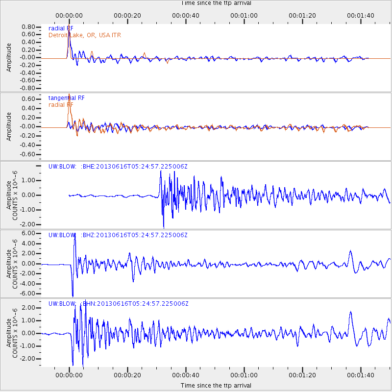
Signal To Noise
| Channel | StoN | STA | LTA |
| UW:BLOW: :BHZ:20130616T05:24:57.225006Z | 41.658085 | 2.4987526E-6 | 5.998242E-8 |
| UW:BLOW: :BHN:20130616T05:24:57.225006Z | 24.66933 | 1.2138387E-6 | 4.9204363E-8 |
| UW:BLOW: :BHE:20130616T05:24:57.225006Z | 16.930141 | 7.402438E-7 | 4.372343E-8 |
| Arrivals |
| Ps | 2.1 SECOND |
| PpPs | 5.1 SECOND |
| PsPs/PpSs | 7.1 SECOND |


