You are here: Home > Network List > UW - Pacific Northwest Regional Seismic Network Stations List
> Station DOSE Dosewallips old TA.C04A, WA > Earthquake Result Viewer
DOSE Dosewallips old TA.C04A, WA - Earthquake Result Viewer
| Earthquake location: |
Guerrero, Mexico |
| Earthquake latitude/longitude: |
18.2/-99.2 |
| Earthquake time(UTC): |
2013/06/16 (167) 05:19:00 GMT |
| Earthquake Depth: |
52 km |
| Earthquake Magnitude: |
5.8 MW, 5.8 MW, 5.9 MB |
| Earthquake Catalog/Contributor: |
NEIC PDE/NEIC PDE-W |
|
| Network: |
UW Pacific Northwest Regional Seismic Network |
| Station: |
DOSE Dosewallips old TA.C04A, WA |
| Lat/Lon: |
47.72 N/122.97 W |
| Elevation: |
53 m |
|
| Distance: |
35.3 deg |
| Az: |
331.91 deg |
| Baz: |
138.469 deg |
| Ray Param: |
0.077158876 |
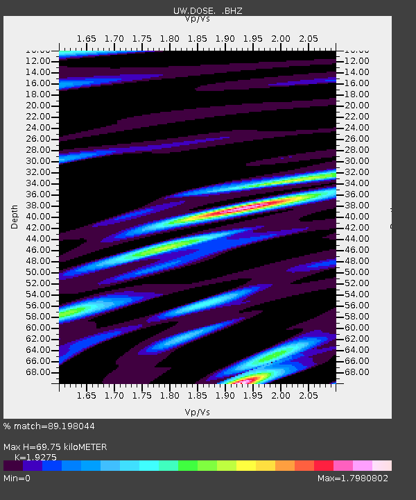
| Estimated Moho Depth: |
69.75 km |
| Estimated Crust Vp/Vs: |
1.93 |
| Assumed Crust Vp: |
6.566 km/s |
| Estimated Crust Vs: |
3.407 km/s |
| Estimated Crust Poisson's Ratio: |
0.32 |
|
| Radial Match: |
89.198044 % |
| Radial Bump: |
400 |
| Transverse Match: |
72.44267 % |
| Transverse Bump: |
400 |
| SOD ConfigId: |
512894 |
| Insert Time: |
2013-09-15 05:46:16.864 +0000 |
| GWidth: |
2.5 |
| Max Bumps: |
400 |
| Tol: |
0.001 |
|

Signal To Noise
| Channel | StoN | STA | LTA |
| UW:DOSE: :BHZ:20130616T05:25:19.774994Z | 15.324041 | 1.0042926E-6 | 6.553706E-8 |
| UW:DOSE: :BHN:20130616T05:25:19.774994Z | 9.527051 | 5.195022E-7 | 5.4529174E-8 |
| UW:DOSE: :BHE:20130616T05:25:19.774994Z | 11.384424 | 7.025939E-7 | 6.171537E-8 |
| Arrivals |
| Ps | 11 SECOND |
| PpPs | 29 SECOND |
| PsPs/PpSs | 40 SECOND |


