You are here: Home > Network List > TA - USArray Transportable Network (new EarthScope stations) Stations List
> Station I45A Fountain, MI, USA > Earthquake Result Viewer
I45A Fountain, MI, USA - Earthquake Result Viewer
| Earthquake location: |
Crete, Greece |
| Earthquake latitude/longitude: |
34.3/25.2 |
| Earthquake time(UTC): |
2013/06/16 (167) 21:39:05 GMT |
| Earthquake Depth: |
19 km |
| Earthquake Magnitude: |
6.0 MW, 5.7 MS, 5.8 MW, 5.9 MB |
| Earthquake Catalog/Contributor: |
NEIC PDE/NEIC PDE-W |
|
| Network: |
TA USArray Transportable Network (new EarthScope stations) |
| Station: |
I45A Fountain, MI, USA |
| Lat/Lon: |
44.04 N/86.23 W |
| Elevation: |
215 m |
|
| Distance: |
80.1 deg |
| Az: |
317.03 deg |
| Baz: |
51.439 deg |
| Ray Param: |
0.048468374 |
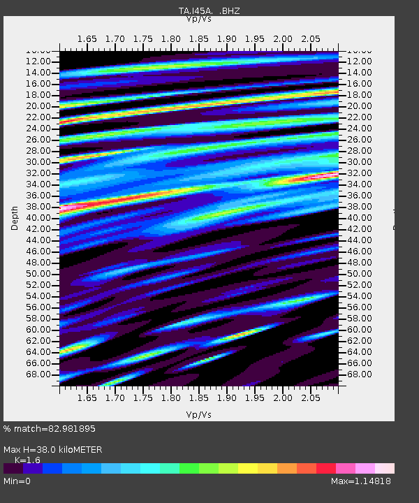
| Estimated Moho Depth: |
38.0 km |
| Estimated Crust Vp/Vs: |
1.60 |
| Assumed Crust Vp: |
6.53 km/s |
| Estimated Crust Vs: |
4.082 km/s |
| Estimated Crust Poisson's Ratio: |
0.18 |
|
| Radial Match: |
82.981895 % |
| Radial Bump: |
400 |
| Transverse Match: |
57.29021 % |
| Transverse Bump: |
400 |
| SOD ConfigId: |
512894 |
| Insert Time: |
2013-09-15 06:18:15.433 +0000 |
| GWidth: |
2.5 |
| Max Bumps: |
400 |
| Tol: |
0.001 |
|
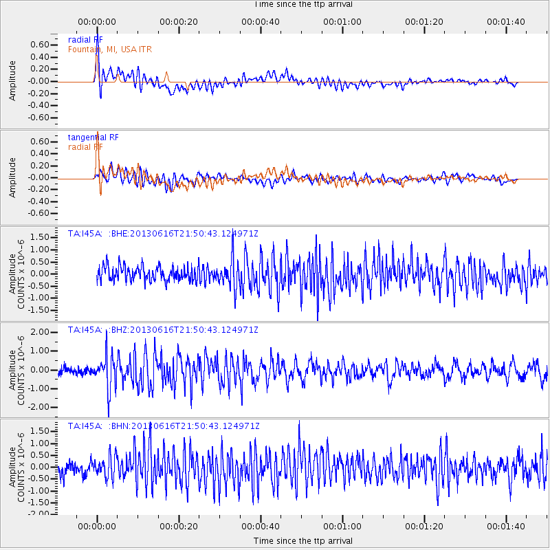
Signal To Noise
| Channel | StoN | STA | LTA |
| TA:I45A: :BHZ:20130616T21:50:43.124971Z | 4.7268653 | 8.7526814E-7 | 1.8516883E-7 |
| TA:I45A: :BHN:20130616T21:50:43.124971Z | 1.6453203 | 4.4727486E-7 | 2.718467E-7 |
| TA:I45A: :BHE:20130616T21:50:43.124971Z | 2.011048 | 5.7832193E-7 | 2.8757242E-7 |
| Arrivals |
| Ps | 3.6 SECOND |
| PpPs | 15 SECOND |
| PsPs/PpSs | 18 SECOND |


