You are here: Home > Network List > TA - USArray Transportable Network (new EarthScope stations) Stations List
> Station R53A Hurricane, WV, USA > Earthquake Result Viewer
R53A Hurricane, WV, USA - Earthquake Result Viewer
| Earthquake location: |
Crete, Greece |
| Earthquake latitude/longitude: |
34.3/25.2 |
| Earthquake time(UTC): |
2013/06/16 (167) 21:39:05 GMT |
| Earthquake Depth: |
19 km |
| Earthquake Magnitude: |
6.0 MW, 5.7 MS, 5.8 MW, 5.9 MB |
| Earthquake Catalog/Contributor: |
NEIC PDE/NEIC PDE-W |
|
| Network: |
TA USArray Transportable Network (new EarthScope stations) |
| Station: |
R53A Hurricane, WV, USA |
| Lat/Lon: |
38.33 N/81.95 W |
| Elevation: |
294 m |
|
| Distance: |
81.1 deg |
| Az: |
310.456 deg |
| Baz: |
53.178 deg |
| Ray Param: |
0.047836877 |
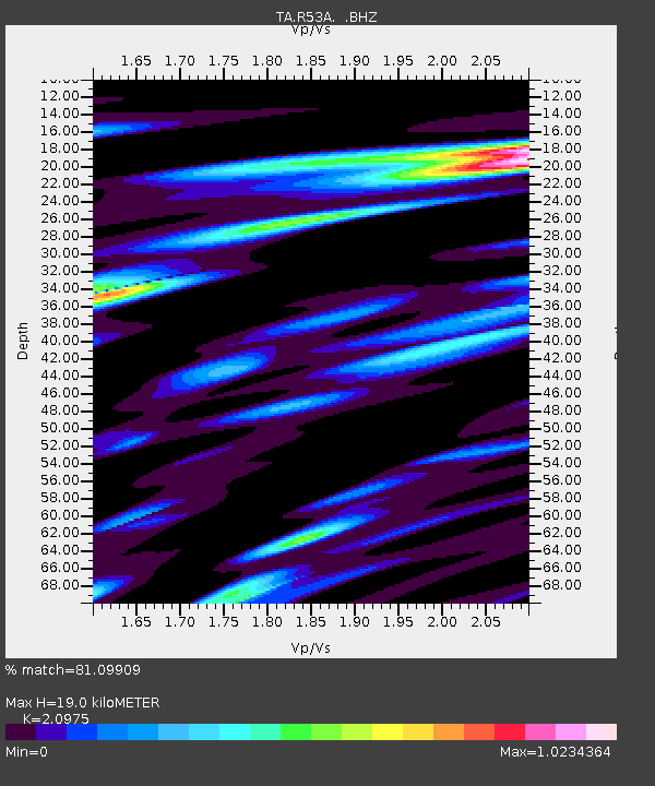
| Estimated Moho Depth: |
19.0 km |
| Estimated Crust Vp/Vs: |
2.10 |
| Assumed Crust Vp: |
6.207 km/s |
| Estimated Crust Vs: |
2.959 km/s |
| Estimated Crust Poisson's Ratio: |
0.35 |
|
| Radial Match: |
81.09909 % |
| Radial Bump: |
391 |
| Transverse Match: |
63.727974 % |
| Transverse Bump: |
400 |
| SOD ConfigId: |
512894 |
| Insert Time: |
2013-09-15 06:24:54.248 +0000 |
| GWidth: |
2.5 |
| Max Bumps: |
400 |
| Tol: |
0.001 |
|
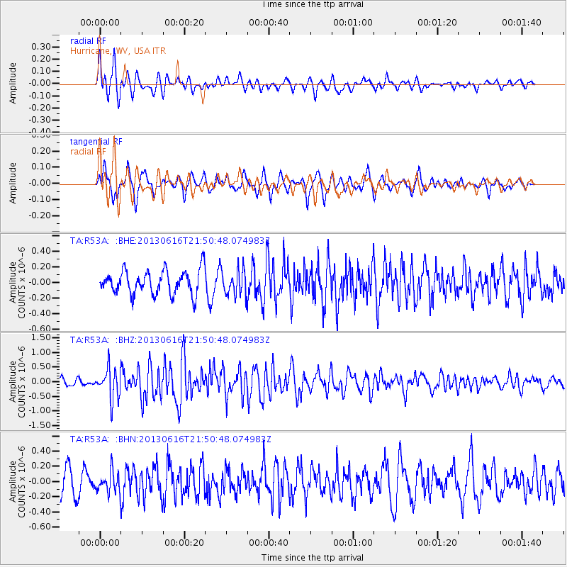
Signal To Noise
| Channel | StoN | STA | LTA |
| TA:R53A: :BHZ:20130616T21:50:48.074983Z | 2.777335 | 5.2433387E-7 | 1.8879028E-7 |
| TA:R53A: :BHN:20130616T21:50:48.074983Z | 0.77405226 | 1.3567862E-7 | 1.7528355E-7 |
| TA:R53A: :BHE:20130616T21:50:48.074983Z | 1.044875 | 1.6068874E-7 | 1.5378752E-7 |
| Arrivals |
| Ps | 3.4 SECOND |
| PpPs | 9.3 SECOND |
| PsPs/PpSs | 13 SECOND |


